Sunday 3rd March
It was a big day for buses in London yesterday.
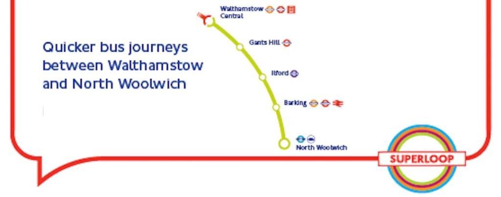
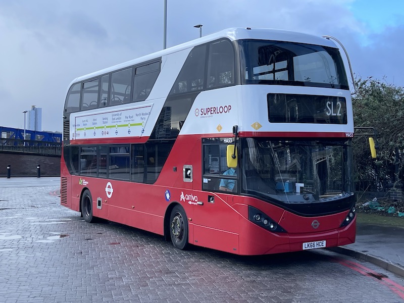
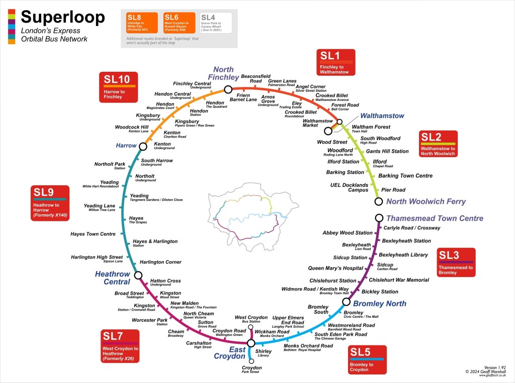
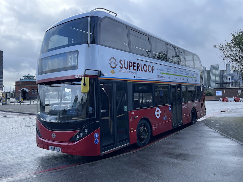
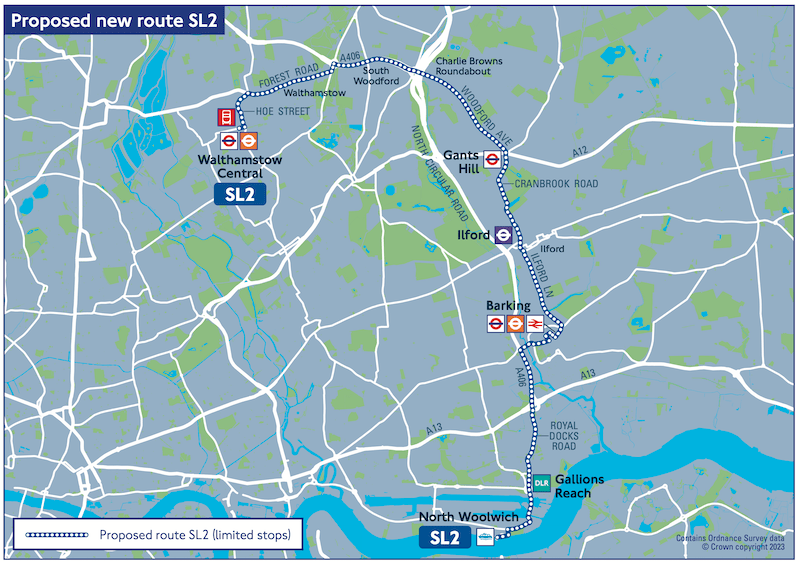
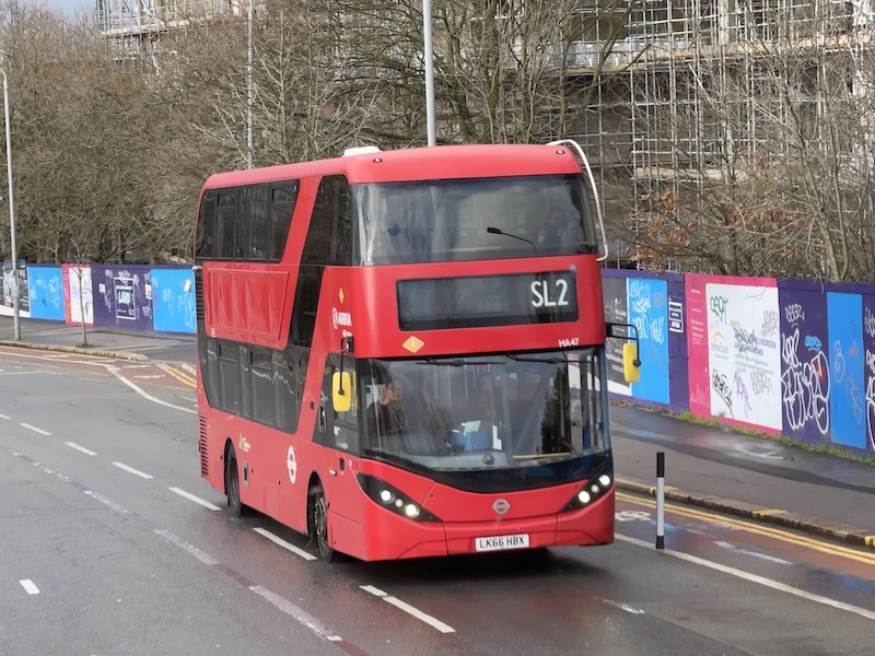
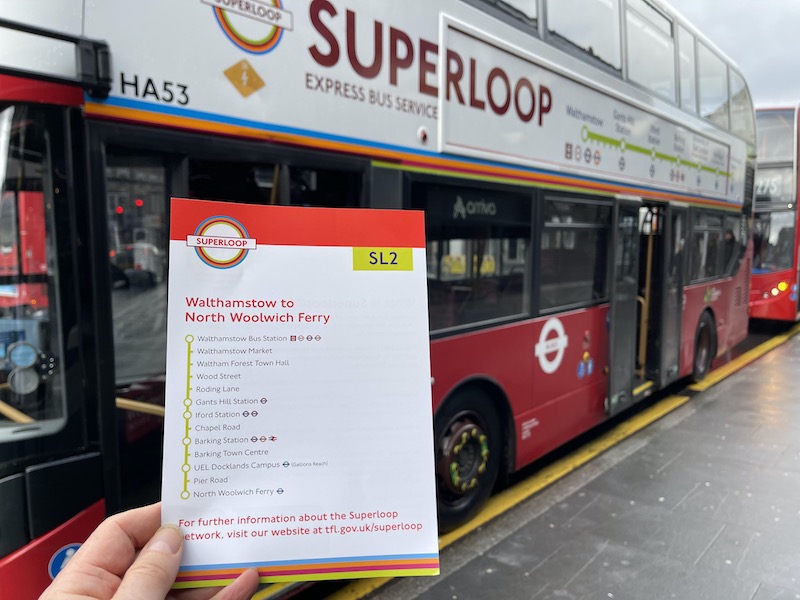
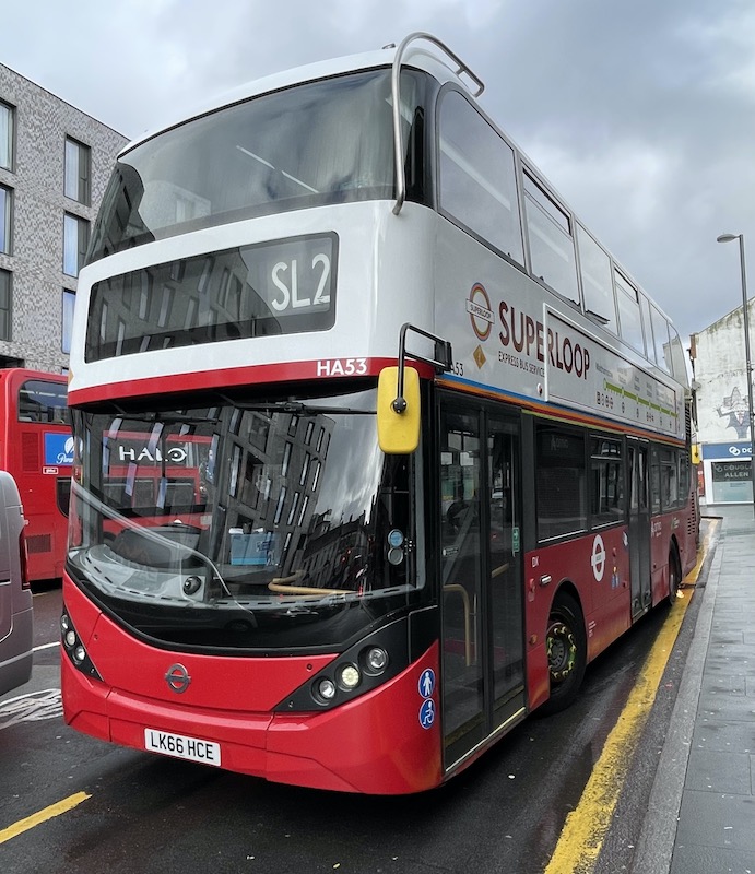
As well as the final orbital segment of Superloop taking to the road with new route SL2 running every 12 minutes between Walthamstow and North Woolwich, completing the 1pm to 3pm clock face…
… a raft of changes to bus routes in the Croydon and Sutton area were finally introduced three and a bit years on from their public consultation.
And it’s not often two new bus routes numbered S2 and SL2 get introduced on the same day on opposite sides of London.
But first, let’s take a look at that final piece of the Superloop jigsaw, route SL2.
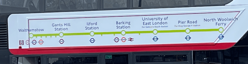
It’s another significant uplift in resources – a Peak Vehicle Requirement of 16 vehicles – alongside no compensating reductions in parallel routes adding significantly to the network provision especially on the busy corridor between Gants Hill, Ilford and Barking, the former of which is served by a multitude of bus routes while the latter sees the high profile East London Transit branded EL1 – which was once the future – and the 169. (I can’t help wondering what passengers will make of an EL2 and SL2 in Barking.)
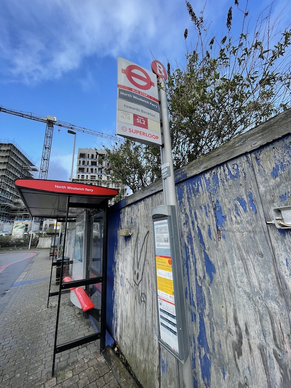
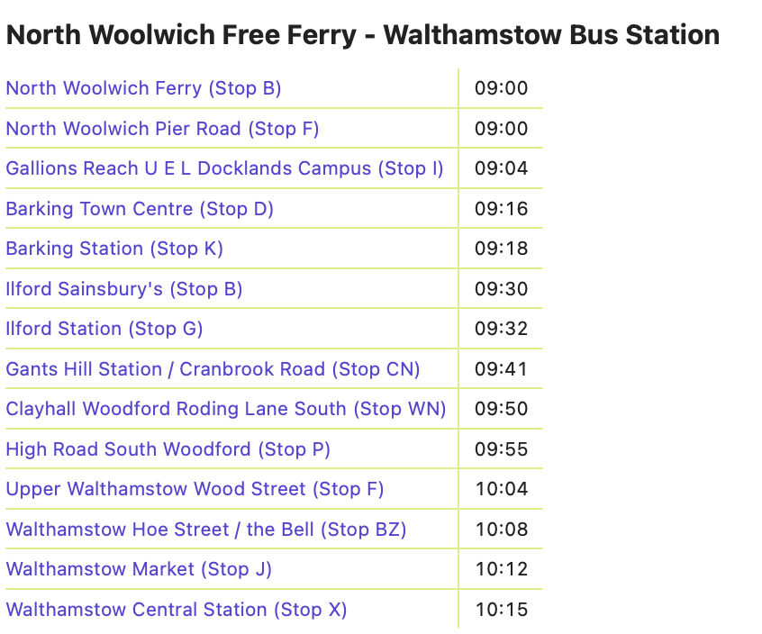
West of Gants Hill the SL2 duplicates the 123 from soon after it leaves its Walthamstow Central bus station terminus (along Forest Road and Woodford Avenue) via Gants Hill to Ilford while after Barking it parallels the 366 via Gallions Reach and then makes its way via route 474 to terminate at the North Woolwich Free Ferry crossing.
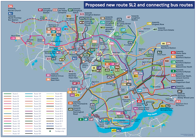
During the consultation for the SL2, TfL produced a formidable map showing how the new route will interact with 48 other bus routes it meets along its path. I’m not sure how helpful this was but it’s certainly colourful.
I took a ride from North Woolwich to Walthamstow yesterday morning and four things quickly became apparent.

Firstly although the E-plate team had been out sticking SL2 and the word Superloop on bus stop flags, the bus stop timetable posting team hadn’t done their stuff at all with no timetables on display along the route ….
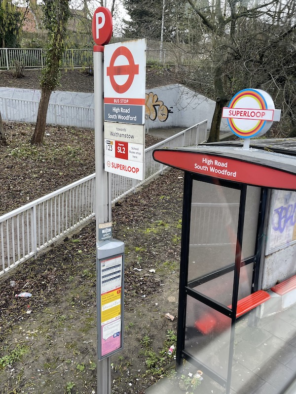
… nor at the termini…
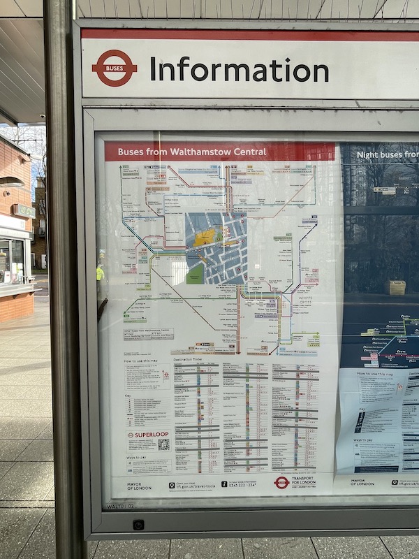
… and out of date spider maps, even in Walthamstow bus station.
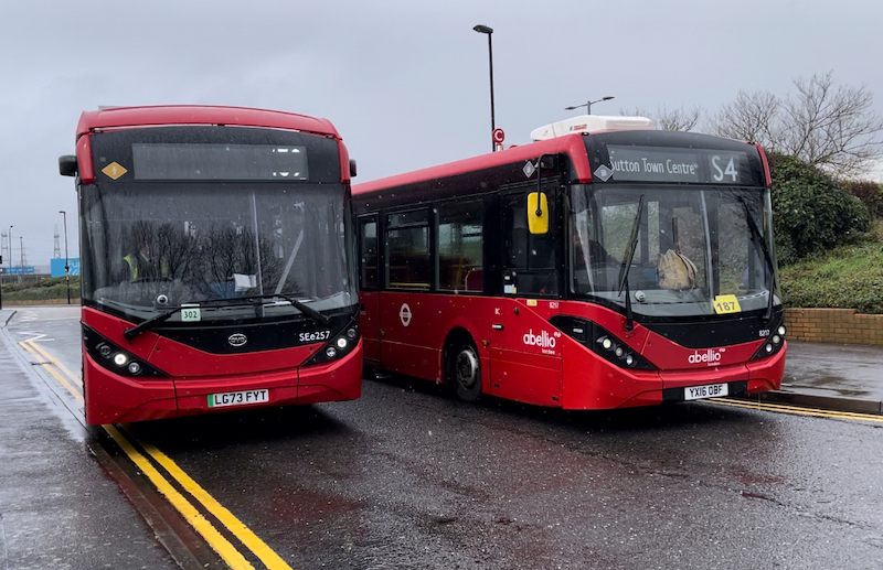
Secondly new destination blinds for the buses based at Arriva’s Barking garage hadn’t been fitted with all buses on the route yesterday displaying blank destinations…
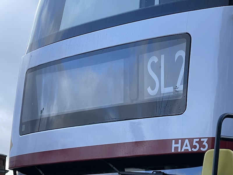
… and only a very few had their Superloop branding added.
I understand the buses were deployed on another route until Friday but there’s really no excuse for sending buses out on launch day of a brand new high profile route and not showing where they’re going on the front, especially with bus stops devoid of information too.
Thirdly the running time early on a Saturday morning (09:00) is far too generous.
By Walthamstow Hoe Street/The Bell we were 16 minutes early as indeed we were arriving into Walthamstow Central Station at 09:59.
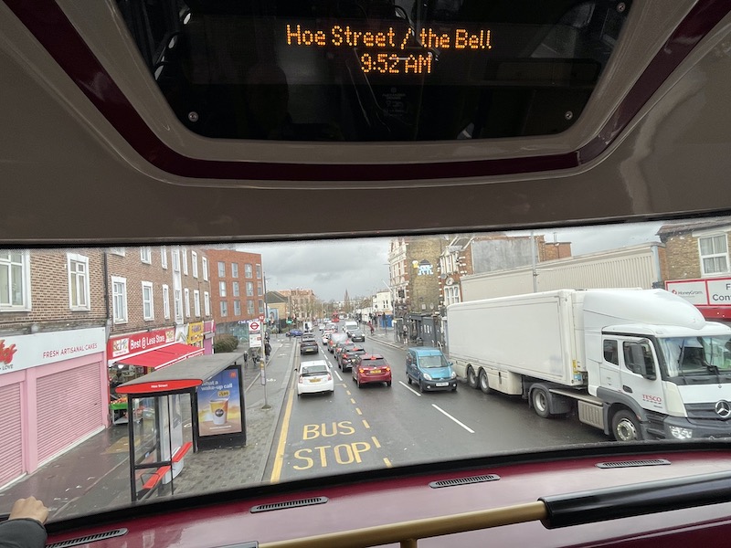
Although we’d sauntered along and waited for a minute or two a few times, luckily we weren’t held at bus stops for a substantial time as it seems all buses were running early so the route was being managed on headway with drivers reaping the benefit of longer layovers. Over the lunch time period buses are given 82 minutes running time. I doubt they’d need that much even though traffic would be heavier. A peak weekday journey has 80 minutes.
The end to end mileage is 12 miles, so my 09:00 journey managed a paltry 12mph. That’s not an ‘express’ route.
And fourthly the application of the branding on the buses looks slapdash and unprofessional.
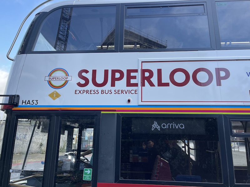
The advertising frames really should be removed as it just looks ridiculous to have the writing over the edges.
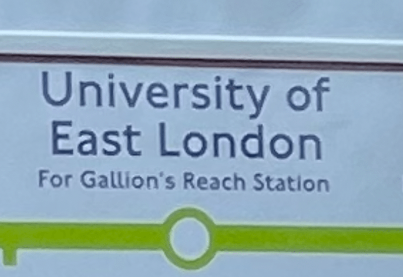
And no-one proof checked the names as it’s Gallions Reach, not Gallion’s Reach.
At least it’s spelt right on the leaflet being handed out by the high-viz wearing ambassadors at some of the bus stops.
However notwithstanding those shortcomings, I reckon the SL2 will soon catch on having just 11 intermediate stops and very attractive non-stop sections between Barking and Ilford and between Ilford and Gants Hill although that’ll only work if buses don’t get bogged down in congestion on that busy corridor.
It’ll be interesting to see how it gets on in the morning peak period as well as seeing how the completed “loop” (that’s not a complete loop, of course) gels together. Something for a future blog.
Meanwhile over in Croydon and Sutton, as explained, most of yesterday’s changes had been consulted on back in October, November and December 2020 with an update on intentions to go ahead published in September 2021. It’s quite incredible how long such things take to implement in a contracted, regulated environment. Many reasons to make changes to bus routes in a dynamic and changing world could well have changed again in the three and a half years and more since the plans were first formulated.
It was so long ago I had to remind myself what I wrote in a blog assessing the changes way back in October 2020.
Minor changes had been introduced to route S1 in the St Helier area back in May 2022 and one significant change – splitting route 407 (Sutton via Croydon to Caterham) in Croydon with a new route 443 taking over the Croydon to Caterham section – has yet to materialise with no explanation about what’s happened to it. Some other reroutings in the Belmont area serving new residential developments are also yet to be implemented.
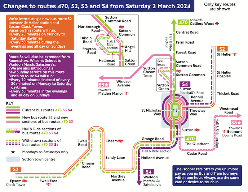
However, one route has been withdrawn and there are two new routes, but no roads are left without a bus nor are any new roads being served. The changes just involve a rather complex reconfiguration of existing routes.
As part of the consultation TfL produced some helpful maps to explain the proposals, here’s just one …
… and in an unusual move has just produced another set to help passengers understand yesterday’s changes. You can see them posted at some bus stops …
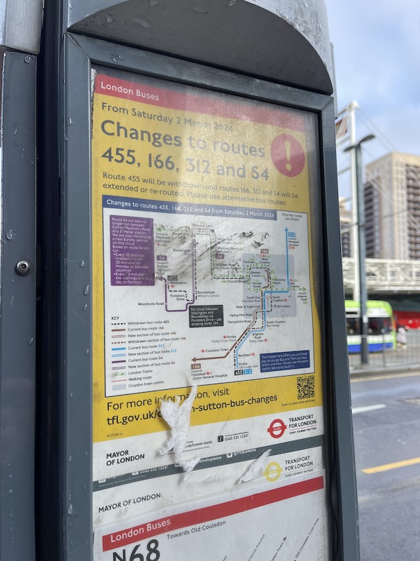
… or you can seek them out on TfL’s website but I’m not sure you’ll be much the wiser when you do find them. They’re rather formidable looking, and more complicated to understand than the consultation maps.
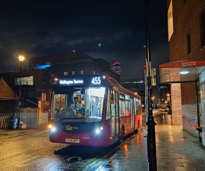
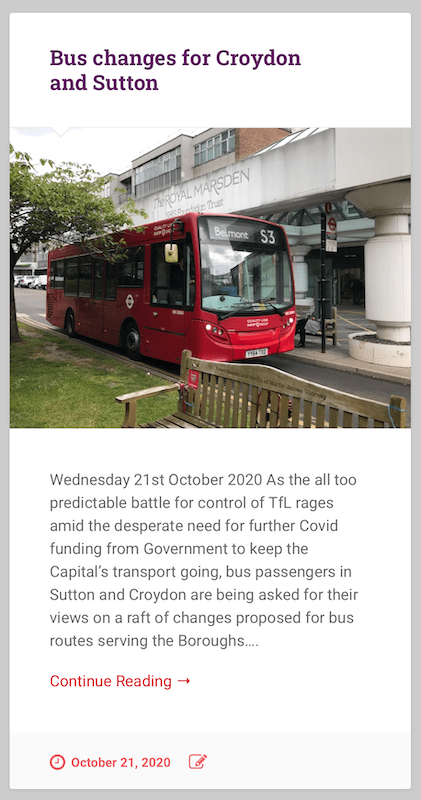
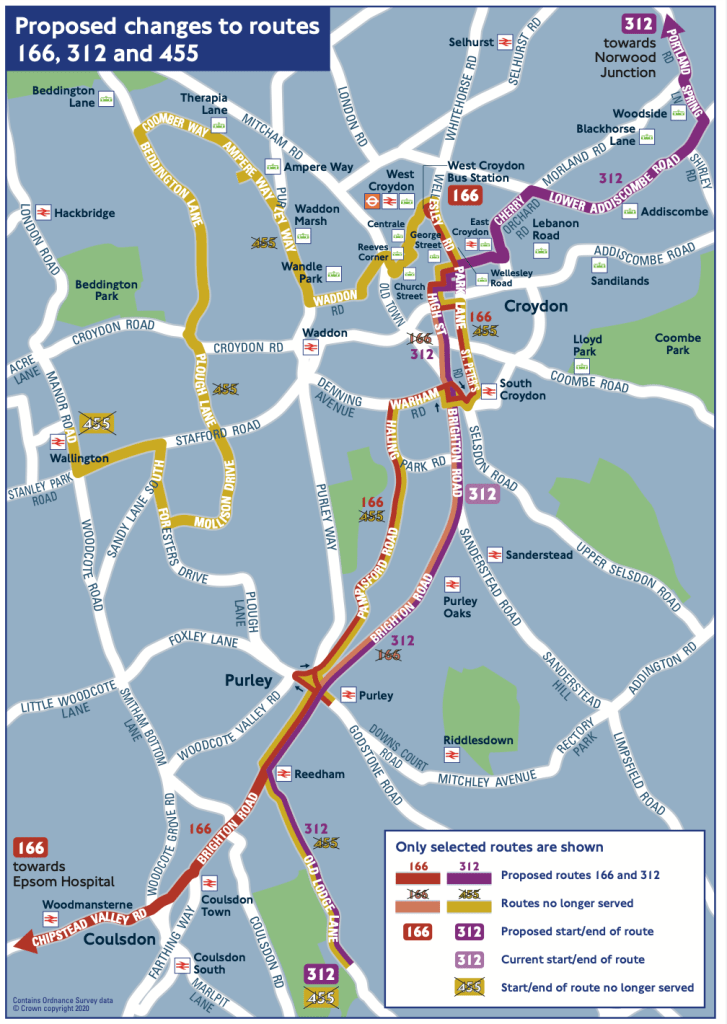
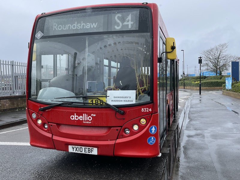
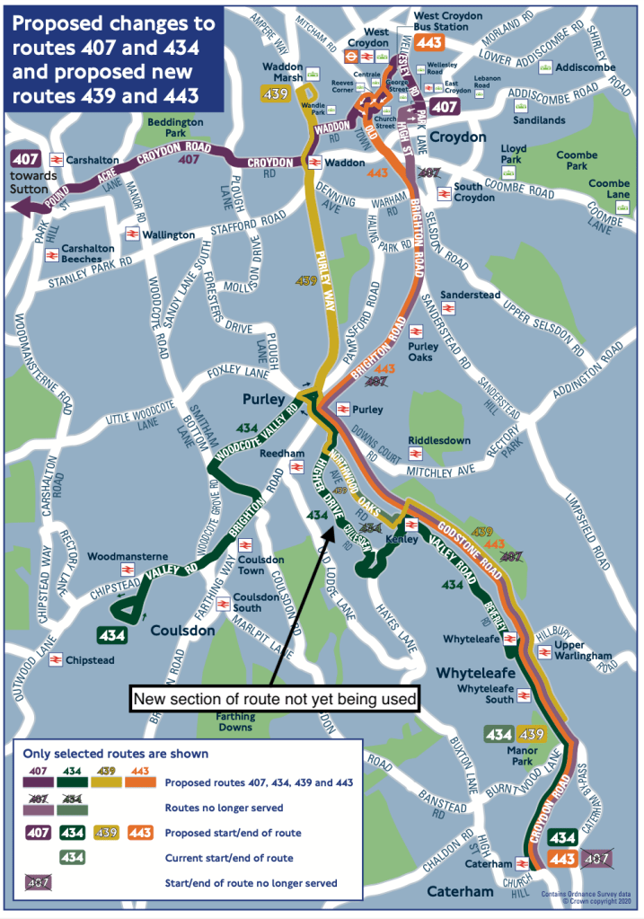
For example, the route that’s been withdrawn – the 455 (photographed on its last journey on Friday above) – is replaced by changes to three existing routes – 166, 312 and S4. Here’s the map to explain it.
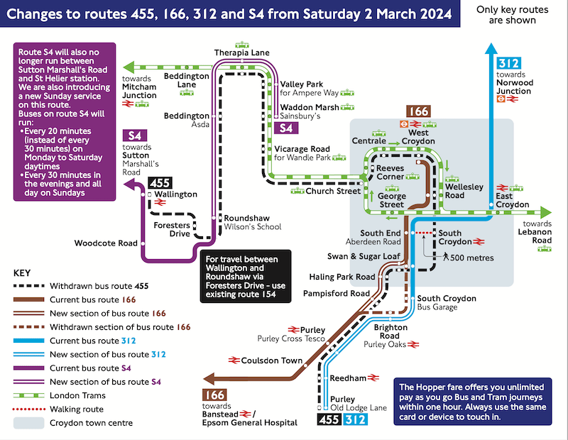
In essence the purple S4 has been extended beyond Roundshaw to Waddon Marsh; the brown 166 is diverted on its way to Purley Cross Tesco from the parallel Brighton Road and the blue 312 is extended beyond South Croydon bus garage to Purley Old Lodge Lane.
The bit of the 455 route uncovered after Wallington and between Waddon Marsh and Croydon are largely covered by other routes, not shown, or the tram.
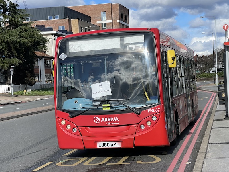
As you can see, like the SL2, buses on the S4 and 312 were running round yesterday without updated destination blinds giving a very unprofessional image
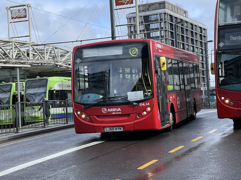
Again, I understand buses on the 312 were deployed on another route (the 325 in East London) until Friday night but whatever happened to staff working overnight to ensure things like this were attended to? Such appalling presentation would never have happened in the old London Transport days.
There was a proposal to divert route 434 south of Purley to serve bus devoid roads between Purley and Whyteleafe (Higher Drive and Cullesden Road) where new residential development is underway as shown on the map in the 2020 consultation (below).
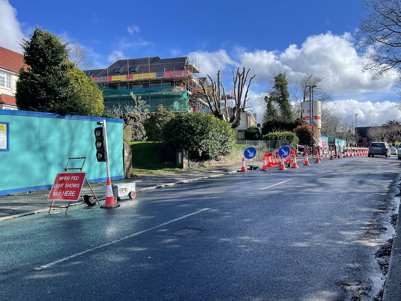
This proposal has been postponed but I’m not sure why – again there’s no explanation – as having taken a wander along Higher Drive yesterday …
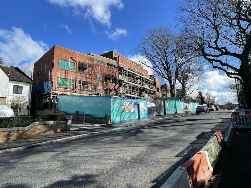
… there didn’t seem to be any impediment for buses to use the new route with traffic flowing freely, albeit with temporary traffic lights.
Perhaps the idea has been dropped? Which would be a shame as there are many houses on the proposed new route more than 400 metres away from an existing bus stop as my rough map below might demonstrate.
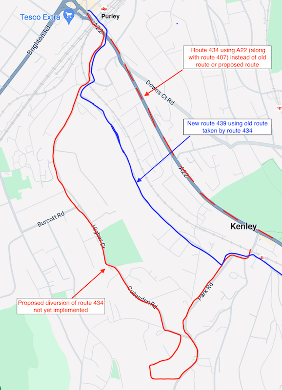
Route 434 is instead using Godstone Road along with the 407 (which as explained earlier continues to run) as shown on the updated map below, so is adding unnecessary mileage duplicating an existing route, as well as being extended from Whyteleafe Wapses Lodge Roundabout to Caterham.
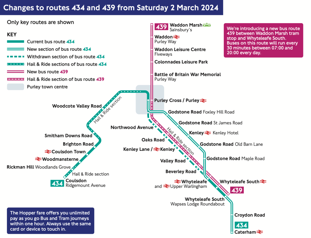
One of the two new routes introduced yesterday – numbered 439 – is also shown on the above map which connects Waddon Marsh with Purley and then takes over the former 434 routing as far as Whyteleafe Wapses Lodge Roundabout.
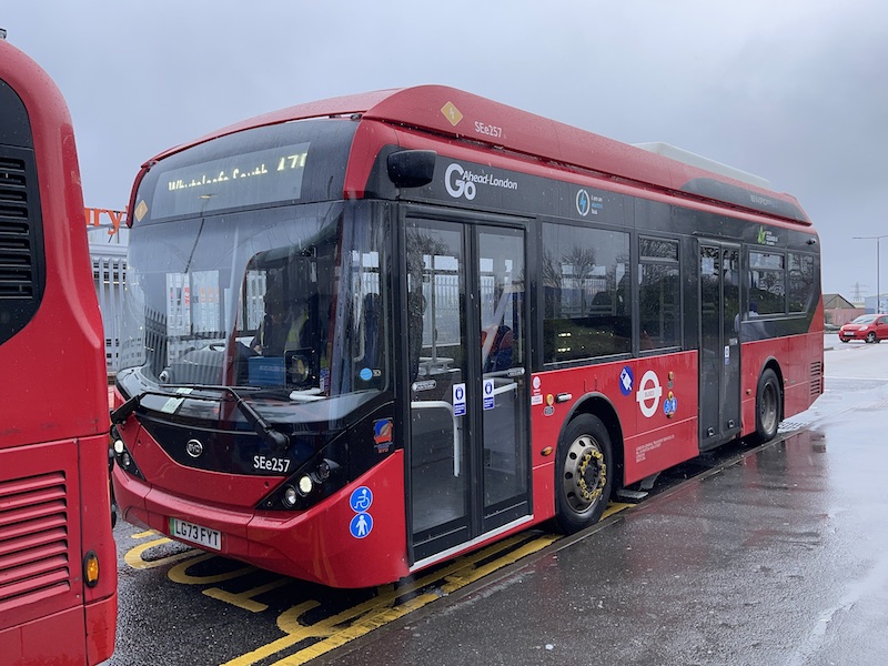
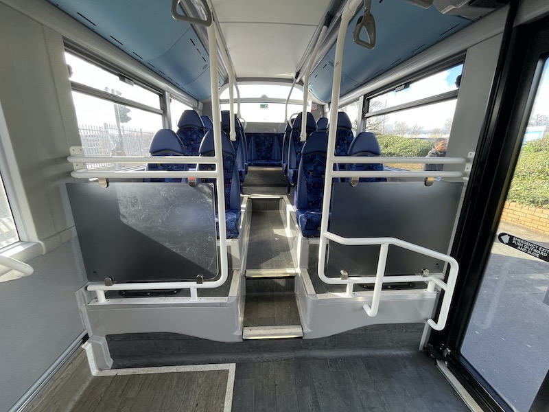
Go-Ahead London are operating it with new electric BYD ADL Enviro200EV buses including a nice smart interior …
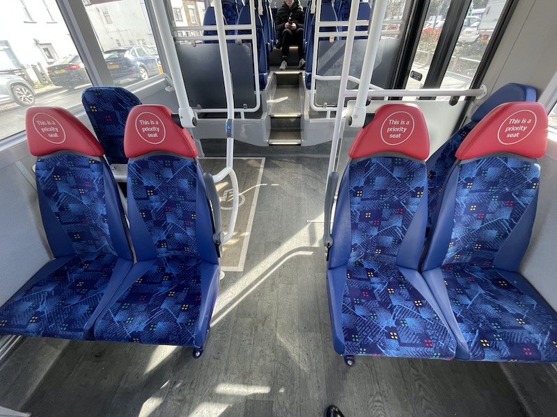
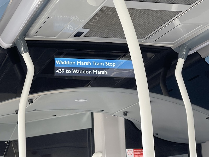
… with new red headrests to indicate priority seating and improved next stop displays.
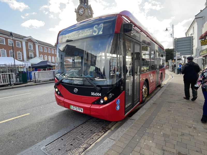
Yesterday’s other new route is the (orange) S2 which takes over the northern end of the (purple) S4 between St Helier and Belmont, as shown on another formidable map, before continuing to Epsom to replace the (green) 470, which is cut back to Sutton. The latter change wasn’t part of the 2020 consultation so I’m not sure how that works, something happening without consultation?
It’s also operated by Go-Ahead London with electric BYD ADL Enviro200EV buses.

It was good to see Surrey County Council had installed updated timetables at bus stops in Epsom for the S2…
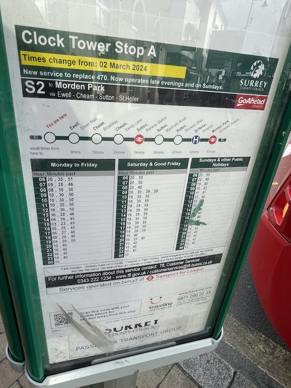
… but it was noticeable how lacking they were in TfL territory even though the E plate team had been out and done their stuff. Albeit in some cases a bit too much, as my friend Geoff spotted as we walked along Waddon Road previously served by the withdrawn 455 on its twiddly route around Croydon town centre but not served by the 439.
It made us wonder how many other bus stop plates around Croydon town centre had errant 439 plates added.
Some timetables had been updated, for example the 312 now going to Old Lodge Lane every 12 minutes (instead of the 455 every 20 minutes) was correct at East Croydon station…
… and an S2 and S4 were correct at Sutton station.
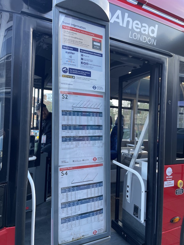
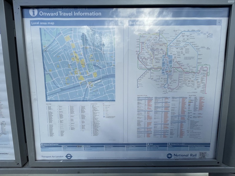
But obviously the Onward Journey rather faded spider map outside the station itself was out-of-date and I suspect will be for some considerable time.
And if all that lot doesn’t confuse you then one other change (included on the ‘inset’ on the map shown earlier) involves routes S3 and 470 swapping routes between Sutton Common Road and Sutton Green…
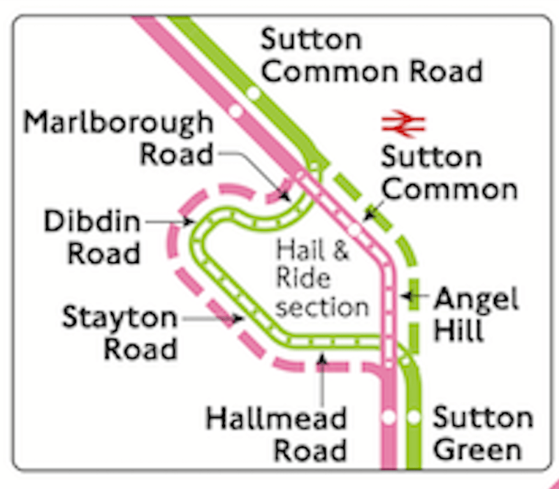
… except TfL’s explanation gets muddled and reckons the S3 replaces the S3.
Despite all this I’m sure everyone will soon get used to the new arrangements. They always do. But an updated traditional network bus map really would help – just like the Underground map being regularly updated – and quite why TfL continues with its head-in-the-sand attitude of ignoring the need for a bus map is beyond me.
It can’t be the cost having just introduced 31 buses to two new routes in the last two weeks at an annual cost of at least around £5 million together with off-peak Fridays from next Friday until the end of May (£24 million) and a fares freeze (£123 million). A bus map design and production could be achieved for about £100,000 which is chicken feed compared to the millions just described.
It might just attract a few passengers otherwise unaware of the orbital Superloop network now available.
Roger French
Blogging timetable: 06:00 TThS.
Comments on today’s blog are welcome but please keep them relevant to the blog topic, avoid personal insults and add your name (or an identifier). Thank you.

I fully agree with everything said and it is certainly very unprofessional with the lack of proper blind displays. The boards in the window are not very visible, assuming they are actually displayed. Just as the 455 did in Purley buses on route 312 should do partly “double runs” in Purley serving the stops for Purley Station/High Street but whilst there are timetables and countdown displays there are no eplates. I did notice a couple of buses which may or may not have been on the 312 failing to do this “double run”. With regard to the SL2 my journey yesterday from WW to NW took about 90 minutes but, in my view, there is still too much private traffic clogging up the roads, clearly adding to bus unreliability. The lack of branding and blinds on the SL2 has certainly let the side down.
LikeLike
I do trust the public “get used to the new arrangements quickly”, as some of these changes seem odd and I would hate to be a Driver involved come Monday morning on the affected routes. Why a quiet backwater such as Old Lodge Lane needs an uplift from 20′ to 12′ seems wasteful, and diverting the 166 away from passing the changeover point outside South Croydon garage will add cost. Presumably, the 312 have lost their electric buses as unable to be charged during the day? As it has taken three long years from “consultation” to implementation, why oh why could they have not waited just a few extra weeks to ensure blinds/(street)maps/stops etc were ready?
The lack of blinds for SL2 of course underlines the speed with which the Superloop scheme has been introduced, a refreshing and welcome change for once. Sadly, in contrast to SL3 and 5, where running times seem fit for a limited stop service, it appears a different team worked on the SL2 timings. One hopes that they soon get tightened if necessary, but difficult in the TfL regime where contract prices presumably have already been agreed.
Terence Uden
LikeLike
North Woolwich does seem odd as the ultimate destination for the SL2 considering that the area is pretty dead and has been since the last of the docks closed in the early 1980s. Surely London City Airport would have been a better traffic objective giving a more convenient connection to the DLR than ‘Ice Station Zebra’ at King George V. Also odd that the Shopping Centre at Gallions Reach isn’t served or even the stop outside it. The quick route to Barking is sensible as this will be beneficial to the UEL campus but I agree that traffic congestion on the route is likely to be a operating challenge. On the publicity front TfL have previously (excuse the pun) pulled out all the stops to get this done in time on the SL routes (unlike the central London changes) but the political decision to rush this one has obviously had its consequences.
Martin W
LikeLike
It’s unfortunate that while you rightly point out the errant apostrophe in “Gallion’s” you include reference to “off-peak Friday’s” in your text. Typos, eh? Can’t live with ’em, can’t avoid making ’em!
LikeLike
Sorry. Forget to leave a name on that comment..
Memory, eh? Can’t live without it, can’t make it work.
John
LikeLike
Thanks for spotting that John. Me and apostrophes go back a long way so I know how the Gallion’s Reach person feels too! Now corrected. (Mine, not the SL2 bus side!)
LikeLike
Didn’t you mean ‘forgot’ and not ‘forget’? Grammar, eh? Glass houses and stones …..
Bill
LikeLike
O Roger, what a mess !! The Croydon/Sutton changes. The only benefit I can think of regarding the 470/S 3 is for the drivers. Certainly not the traveling public – and think of the expense in making all these unnecessary changes! S 2/S 4 again what is the point ?
The withdrawal of the 455, about the worst decision that could have been made, the traveling public along Old Lodge Lane are now restricted to a service to central Croydon (who wants to go there anyway- it`s a dump) so, no longer a direct service to Purley Way and beyond ! If God was to grant me half a dozen wishes, one of them would be bring back the 455. There is now a section of road that is no longer served by buses – St. Peter`s Road. No, I do not use it regularly as I live in West Wickham where we have a very good café – vegan, only beans on toast or avacado on toast for you as far as I can tell.
The 439, another unnecessary route. From Waddon Marsh to Purley is covered by the 289 and is very quiet for loadings. Yes, I am aware that new roads will be covered in due course. Why o why did they not keep the 434 as it was, and put the 439 over the new roads – would have been simpler. Also, why a new route anyway ? Extend the 359 over the new roads, it is a very short route anyway.
Purley Way : From Waddon New Road, to Mitcham Road there is now only the long winded, time consuming 289 into Croydon. Some arrogant twerp from TfL said there is the tram – not the most convenient for disabled travellers ! Some people do not like trams for whatever reason. also insufficient seats. Perhaps a third carriage would solve this problem ! An official ? spokesman also said the good people of Wallington/Roundshaw could use the 154 instead to get into Croydon.
And diverting the 166 along Pampisford Road, why ? this is a quiet residential road, so why does it need two routes on it ? And each uses the exactly the same routeing Croydon to Purley. Having used the 166 to Banstead/Epsom I can say that on those occasions I have seen passengers board the route on Brighton Road that go beyond Coulsdon, and even Chipstead. Another unnecessary inconvenient change.
Another thing that “gets my goat” is so many changes – no stability in London`s bus services anymore. It can only be to keep the staff in a job. If only we could go back to L.T. days whereby changes were made three times a year, March, July and October.
Regarding bus maps for London`s buses – is it beyond the wit of TfL to do a deal with Mike Harris ? Perhaps they could be made available at Enquiry offices and Under/Over ground stations and major railway stations south of the river for those without a under/over ground line ? With your standing in the industry can you not suggest this to the Commissioner ? Then TfL would not need to have staff to create/maintain the map, keeping expenses down whilst providing the bus user with what they deserve.
Finally I watched the whole of your webinar – must watch it again. I was surprised at your positive attitude to “branding” bearing in mind your criticism of branded buses being on “wrong route” My thinking is; use L.E.D. blinds more efficiently by using colour – each route could be colour coded thereby “branding” each route rather than just some – I think this could be helpful for partially sighted people as often the bus has to be “on top of them, so to speak” before they can read the number or destination, Only the route number needs to be done. For colour blind people, well I assume that they can read clearly from a distance. Where numerous routes exist in the same area, then surely different colour backgrounds could be used ! Red on black, red on blue red on green et cetera.
With great respect,
Brian Hawkins.
LikeLike
In the early days of The Greater London Bus Map I used to have a good relationship with the Travel Information staff and most of the Centres took copies of the map to sell to customers (and make a percentage of the sales in commission). However over the years, with the decline in centres and staff leaving, I struggled to get them to take copies, usually receiving the response ‘nobody asks for them’. Of course the reason for that was the maps were kept literally under the counter, and sadly not on display with all the various tours’ leaflets. If they’d been on display then people would certainly have asked for them, but staff simply weren’t interested. Thankfully the LT Museum still takes regular supplies of the maps, and has them on display at the till point, and this is now the only location where maps can be purchased in person. The TfL marketing department seems to have no interest in promoting the bus network and encouraging travel, as demonstrated by much of the publicity and posters being so out of date, and certainly has no inclination for producing a bus map. They do though have the money to produce a pocket tube diagram twice a year, despite there being no real need as every station and platform has poster maps, and every tube train has line diagrams and central London tube maps.
LikeLiked by 2 people
I have to say Mike I still use your paper maps for reference in getting around London. They are unrivalled & I recommend them to anyone planning a journey. They are far superior to anything TfL produce & many thanks for keeping them going. I think Transport for West Midlands is one of the few organisations still produce comprehensive maps in all formats here in Brum.
LikeLiked by 1 person
Brian Writes…
“Finally I watched the whole of your webinar – must watch it again. I was surprised at your positive attitude to “branding” bearing in mind your criticism of branded buses being on “wrong route” My thinking is; use L.E.D. blinds more efficiently by using colour – each route could be colour coded thereby ‘branding’ each route rather than just some – I think this could be helpful for partially sighted people as often the bus has to be “on top of them, so to speak” before they can read the number or destination, Only the route number needs to be done.”
I’d say branding’s OK if
• the route (or group of routes) doesn’t have diagrams interworked with other routes
• there are unbranded vehicles which can substitute
• wrong brand on any route is regarded as a ‘never event’
For Cambridge there is one branded route – Whippet’s Universal https://busandtrainuser.com/2023/10/21/w-is-for-whippet/
Stagecoach’s Euro VI diesels for the five P&R routes were branded for each route, with a spare (grey) P&R bus. Then came Covid and minimal services, with P&R vehicles (being the newest, most reliable, most efficient) pressed into service on every route.
The 30-strong fleet of electric double deckers on Park & Ride and Citi route 2 were covered by Roger in Seen Around 16 – https://busandtrainuser.com/2023/10/31/seen-around-16/
Roger wrote:
“I quite liked the livery (as used on a pair of BYD/ADL Enviro400EVs since February 2020) with lots of plain white and hope it can be kept clean during the winter but it is a shame to lose the colour coding previously used for the different Park & Ride routes in the city which I thought was very helpful in identifying what bus went where.”
But, hang on, there IS branding! The LED destination displays are in the colours of the former Euro VI diesels’ liveries.
Well, if that passed by Roger without him noticing, I wonder if any member of the travelling public spotted this oh-so-subtle route branding.
LikeLike
Well I benefit from S2 replacing 470. I now have a nearby service on Sunday and in the evening. I did travel Cheam to Colliers Wood a few times…it was purgatory.
LikeLike
Good title and excellent explanation of an otherwise confusing changes.
But I’m also commenting on a surprise two items regarding buses in todays Sunday Times. In itself most unusual but AD are having troubles with BYD in the main paper whilst they are also involved to some extent in Business &Money section where Joe Bamford is rightly challenging the use of taxpayers money meant to support British buyers but used instead to buy from abroad. This is in case you missed it but I doubt that very much since you seem to know pretty much everything and many thanks for that,
Peter D
Sent from my iPad
LikeLike
Bring back the 455
I use it to go to Asda
Josh Welby
LikeLike
The S2 has a timetable header showing Morden Park as a destination, it’s St Helier Station as the bus displays, Morden Park is a 10/15 minute walk further along the road
LikeLike
The latest LOTS newsletter gives the reason for the 434 not yet serving Higher Drive and Cullesden Road – awaiting completion of roadworks at Wattendon Road.
The lack of proper blind displays is indeed poor, and begs the question why London has persisted with printed blinds long after electronic displays have become more-or-less universal everywhere else.
One point to note about the SL2 is that its introduction appears to have been brought forward a week, at short notice (LOTS newsletter lists it as starting on 9th March). Could that explain buses without vinyls and full blinds on the first day? Would it have been better to wait another week? Debatable, I guess. No doubt there is a reason for introducing it a week earlier than previously planned.
Malc M
LikeLike
Find myself in complete agreement with Malc M on the subject of digital -v- printed destination blinds.
Digital blinds have improved in pixel density and visual clarity in leaps and bounds over the last decade. I could see why TfL kept printed blinds for quite some time, but I think the time for the changeover has now come for all new vehicles.
LikeLike
I wonder what Frank Pick would think?
Peter Brown
LikeLike
Many thanks for this twin-subject blog – lots for TfL to meditate on. I wonder if the office concerned with SL2 publicity etc. was suddenly afflicted with covid or flu?
It’s great that almost all the radial rail/tube lines that SL2 crosses have interchanges with it, but sad that the Central line Epping branch is missed. There are a few other ‘gaps’ in the ‘big loop’; I’m not suggesting changing the existing SL routes, adversely affecting timings, but perhaps – as traffic justifies extra frequency – TfL might consider a second ‘layer’ of routes, overlapping the ones we have, but starting/finishing at these missed exchange points: e.g. South Woodford station to Palmers Green station, Palmers Green to Harrow & Wealdstone station, H&W to New Maldon station (maybe avoiding Heathrow, but calling at Harlington corner and Hatton X). TThis would double the frequencies at most SL stops. Sounds a little complex, but the S2 part of your blog shows that TfL are not averse to complexity, and this would be in the cause of Better Connectivity …
LikeLike
Why? You cannot have direct bus routes to and from every place in London
LikeLike
You are desperately behind the times, old fruit.
Who needs printed timetables when we all have mobiles for that sort of thing?
LikeLike
No we don’t “all have mobiles for that sort of thing” – that is a discreditable conspiracy theory.
Ian McNeil
LikeLike
I have a feeling the comment you are replying to was somewhat “tongue in cheek”!
Certainly the lack of destination displays illustrates the complete fallacy of tfl persisting with traditional blinds decades after everyone else switched to LED ones.
I can’t think of many other competent operators or organisations who would have happily rolled out a new “flagship” route in such a messy patchwork manner.
LikeLike
apologies, forgot to sign off that comment
blue
LikeLike
Is TfL still classed at ‘competent’ now?
LikeLike
Fair comment. If I was going to be kind I’d say “hit and miss”…!
blue
LikeLike
While the 470 curtailment wasn’t part of the original proposals, it was part of the amends made as part of the consulation report in September 2021 (page 5 of https://haveyoursay.tfl.gov.uk/11846/widgets/34077/documents/16823)
Rocky
LikeLike
Wait until you learn that they spent nearly £6000 on the livery of each bus. There are some great FOI requests out there to build another article on.
LikeLike
In fairness, that is the market rate of such a vinyl application. And I don’t think anyone would suggest not having any branding?
LikeLike
For once l’d have welcomed Ray S’s work!
LikeLike
Alas, no more Route 455. A long time ago when I refereed matches of the Morden & District Sunday Football League I would use my Travelcard to gratuitously explore bus routes in the area, after my game, including the labyrinthine Waddon and Beddington areas using Route 455 to have luncheon at a supermarket on the way. Kitbag in one hand and my Travelcard in another – what better way to enjoy South London, after a match appointment, than to explore Route 455 and enjoy a meal at a remote supermarket – a Sunday’s bliss!
LikeLike
The 434 change is the most annoying for my children. They will have to walk up and down Foxley Hill Road every day instead of getting the bus. They have also made big changes to the timetables, making the school bus a bit tight for dawdles at Woodcote School. I drove the new route last week and I can’t see any issues except a tight corner where Cullesden Road becomes Firs Road. Those flats in the picture on Higher Drive are 60 for allocation by the council. There are two large new blocks a bit further up as well.
LikeLike
Why doenst TfL just be done with a bus map and use the fantastic services of Mike Harris !!. He produces a most excellent London bus routes map of which i never travel without. He also produces a Night bus map and thats also of the exact quality of the day bus route map.
I just hope that maybe one day he will produce a bus map of the Home Counties, (Essex, Herts, Beds, Bucks, Surrey, and Kent). Now that would be superb and a map or maps to have in the collection and would be an added benefit to the London Bus Maps he already produces.
GN Tel M
LikeLike
Try http://www.busatlas.uk/ . . . a long-term project to cover the whole of England and Wales (and possibly Scotland).
LikeLike
The HCC map on Interlink web site covers much of the home counties North of the Thames
LikeLike
yes……. but is it up to date & showing the new 725, 721 and other new routes introduced between Welwyn GC & Hertford ??
GN Tel M
LikeLike
A brief comment. Living in Cheam, I used the 470 a lot to get to/from Epsom so I’m delighted that S2 runs on Sunday and into the evening. Happily spotted them yesterday morning. S2 signage was in place last week. SL2 good except when it’s the old buses with inadequate storage so suitcases occupy the seats – it does run to/from Heathrow after all.
LikeLike
Are the SL routes generating new demand or are they just abstracting passengers from other routes ?
Given the very high cost of these SL routes they would need to generate a very large increase in passenger numbers to even cover their costs
LikeLike
Re London bus blinds, my beef is the vagueness of the destination. Route 353 for instance shows Ramsden Estate with no mention of Orpington where I believe it is. There are many other instances but at least the 261 has recently been changed from Princess Elizabeth Hospital to Locks Bottom with the PRH underneath.
LikeLike
I noticed the new route S2 today, on my way to work. I will definitely use it, before there was no direct bus route to St Helier Hospital from Epsom without taking the Staff shuttle bus.
The timings for the shuttle H1 bus are not that great, so I will see how this new route compares to it. I think it is a shame that the S2 only runs to the high street in Epsom, & not up to the hospital. This would’ve been a great link between the two sites.
LikeLike
Great blog! I think to rub salt into the wounds a lot of those HAs for the SL2 were parked up at DX so may not have just left another route. But McKenna Bros, the only ones still making the obsolete roller blind tech, so were overwhelmed with work.
So not Arriva’s fault, but the branding could have been rolled out to all (except DW333 and SW3) on the route.
Really should drop Smart Blinds and use LED now, it will prevent embarrassing stuff like this…
LikeLiked by 1 person
Over the past few months the 493 route has suddenly started to suffer from buses with broken destination and route number blinds on the front and side of the buses. Paper route numbers have been sellotaped to the windows but it all looks very poor. Sorry to hear new rotes are also suffering from the problem.
LikeLike
All these references to the S2 bring to mind Metro-Scania and Leyland National saloons at Clapton Pond – and that fateful day that a Metro-Scania ended up in it.
Stuart R
LikeLike
Shame every other outer London borough git a superloop service except Havering, we’ve had a local bus service axed with the replacing it going from a 15 minute peak service to every 20 minutes
LikeLike
Most of Merton’s single deck routes are blinded erractally (and some sutton DD ones) , in part due to the 200 bus electrics being off the road. ( 152/219 mainly with 200 too all having the odd paper route number “blind” only , also affected by such vehicles coming in from other garages around the London General LT empire. at least the frequencies seem pretty good and reliable though (that will change on the 152 when London Road Mitcham gets its gas works up the road kicking in for a few weeks).
Meanwhile the useful 455 is gone, the S2 may be an improvement where it is , but the Colliers Wood / Merton Area was supposed to get a tram to Sutton (hasnt and unlikely to) and the 470 remains half hourly, doesnt work late and doesnt work Sundays – when extra leisure to Morden Hall Park and Abbey Mills etc one would have thought to be useful. The 166 should have gone to every 15 mins with alternate to Epsom to at least encourage travel , Add in the Croydon numberelli spaghetti of 43n and 44n routes that it must be difficult to hold in ones head (even if 400 series bus routes in London Country existed in the green LCBS days I am sure they were easier and more logical to understand. The LED “Blinds” also switch off when vehicle is off – which happens at mid point driver changes and you can arrive at a stop unaware that your bus is about to be fired up and moved off before you have even literally seen it.
Poor Geoff, he should be alright with a general positive spin on the SL2 route ( Gallions shopping area notwithstanding ( and I assume he has to take the ferry and southern side bus to find the SL3 for his vid), but Croydon changes , for a less experienced bus nerd will be hard to get around in ones head. I feel that Croydon deserves its city status, and almost should have say a chocolate and cream livery for its “local” buses with maybe red bus routes (emblazoned “Tilling” to the City and other urban centers,
JBC Prestatyn
LikeLike
Confusion about destinations on buses in the Walthamstow area is spreading to other routes too – the Ilford-bound 123 I caught yesterday was convinced that it was going to North Woolwich! I took a picture of the on-bus info screen but we can’t attach pictures to Comments. Graham L.
LikeLike
The 123 is going to be slightly shortened. TfL are proposing to axe the Turnpike Lane to Wood Green Section. That seems sensible it cuts out a very congested section of the route and should not inconvenience to many passengers
LikeLike
Hi Roger,
To illustrate my Comment, here’s a picture taken yesterday on the 123 that was convinced it was going to North Woolwich!
All the best and keep up the excellent and entertaining work. By the way, have you sampled the strange bus route that serves the isolated new-build estate adjoining Longcross station near Sunningdale? Seems to be a poorly-advertised combination of timetabled commuter runs and on-demand.
Cheers – Graham L.
LikeLike
If you email me the photo Graham – I’ll add it up my month end round up. busandtrainuser@gmail.com.
I’ve had a ride on the Surrey Connect DRT at Longcross but this sounds like something different?
LikeLike
Hi Roger – in fact I’ve already sent it to you, hope you got it OK.
That sounds like the one I was referring to. I went to Longcross on the train last year with my old friend Simon Brown (of Buses Worldwide and others – you may well know each other) and we had a wander round. There was no info at all about the bus service on display anywhere, though we did come across a small non-standard bus stop sign. I had to go online when I got home to find out any details. The railway station isn’t signposted either (on/from the estate or from the main road), and ludicrously its last train is in mid-evening – so the poor isolated folk of Longcross can’t use it to return from a night out in London, Reading or anywhere else. With no shops either, the whole development is designed on the assumption that everyone drives (and doesn’t drink!).
All the best – Graham L.
LikeLike
The situation at Longcross is really quite ridiculous. A housing development next to a railway station and yet we still can’t get it right. There has been some minor work to improve the platforms and waiting areas but how the development has been allowed to come this far without proper access being created I’ll never know.
When SWT changed the timetable in 2004 extra run time was added so that (with a couple of peak exceptions) every train could stop at Longcross. If you look at the time from Virginia Water to Sunningdale it’s the same whether they stop or not so the decision to end services mid evening is inexplicable.
Surfblue
LikeLike
The 407/443 change will no longer be happening, as TfL have decided that this scheme was no longer worthwhile.
LikeLike
Your comment about maps inspired me to draw in an attitude of I’ll-do-it-myself, just a Superloop map, but a detailed all-stops map, and geographical. https://t.co/Dh1MPpo0wh
Either way, had fun drawing. Would be a waste to keep to myself, so anyone who wants to use it, go ahead.
LikeLike
Re timing, the SL2 yesterday (March 9, 2024) took 82 minutes to get from Walthamstow Central to Barking, due to a colossal jam (due to roadworks on, and the narrowness of, Ilford Lane, plus just an overload of traffic). It then abruptly terminated in Barking — the classic double jeopardy of a delayed bus; let’s screw passengers twice over — with our driver promising the next one would continue to North Woolwich. The next one… terminated in Barking. As then did the next one. By now there was a mob of passengers. I decided to take an Uber, and eventually arrived at North Woolwich ferry terminal at 2.39pm, some 109 minutes after leaving Walthamstow.
All of which is to say: maybe the timing isn’t so generous after all!
FWIW: the majority of SL2s remain unbranded (unlike all over services on the route, excepting some SL3s); none have USB sockets (ditto); and the spider map at Walthamstow remains SL-deprived as described above.
LikeLike