Saturday 11th October 2025

Now, this route really is a Bucket List Must Do. Except it’s probably one of Britain’s most challenging bus routes to take a ride on.
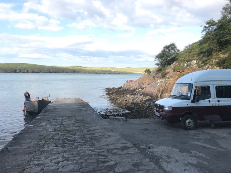
The service only runs in the summer and passengers need to first take a sporadically timed tiny passenger ferry boat run by one ferryman, Mr Morrison, across the Kyle of Durness subject to the tides and weather being favourable; there’s a minimum number of six passengers required before the ferry and then the bus waiting on the other side at West Ferry Point will set off; and thirdly no service will run if the MoD are carrying out military exercises in the area. The bus can’t exceed 15 mph so it takes roughly an hour to complete the 11 mile journey from the ferry jetty to Cape Wrath.

And all that’s assuming you’ve made it to Durness situated in the extreme north western corner of Scotland where public transport is extremely limited – just one journey a day to and from Inverness with another once-a-week service across the top of Scotland to and from Thurso.
But, as I found when I undertook the journey in 2019, all that effort is well worth it as the Cape Wrath bus really is deserving of its title of being Britain’s Second Most Quirkiest Bus Route.

Since I travelled in 2019 information on the ‘Visit Cape Wrath’ website is now much more informative and helpful and warns of all the many pitfalls.
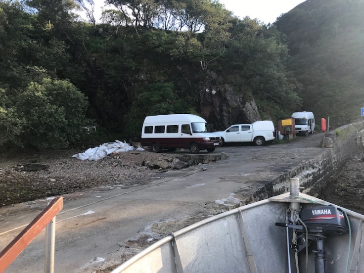
The only vehicle access possible to reach Cape Wrath is the minibus which runs this quirky service. The nearest classified road, the A838, which is part of the ‘North Coast 500’ route, is about a third of a mile from Keoldale jetty from where the passenger ferry departs. There’s no road access for general traffic to Cape Wrath. The minibuses are ferried over to West Ferry Point at the beginning and end of the summer season by the army as part of its logistical exercises.

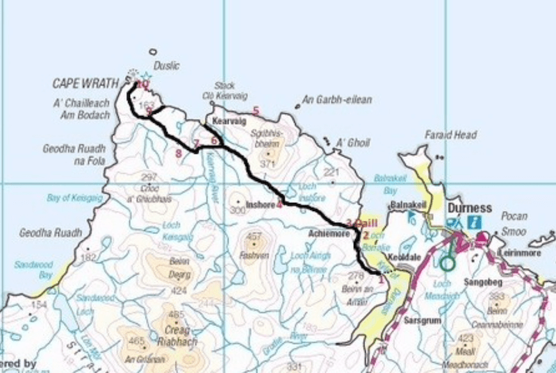
The map below shows the context of the remote area between the A838, the Kyle of Durness and Cape Wrath.

When I made the journey I arrived at the jetty to find no ferry in sight and the tide out. The ferryman was spending the down time fishing in the Kyle waiting for the water to be deep enough to restart the ferry crossings.

Luckily that wasn’t too long to wait, but the next challenge was waiting for five other passengers to turn up before he’d set off. And again luck was on my side as it wasn’t long before others and a friendly dog arrived…
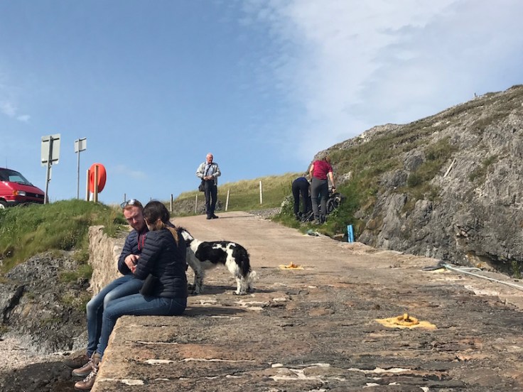
… and the ferryman came over from West Ferry jetty with returning passengers who made it over in the morning before the tide went out.
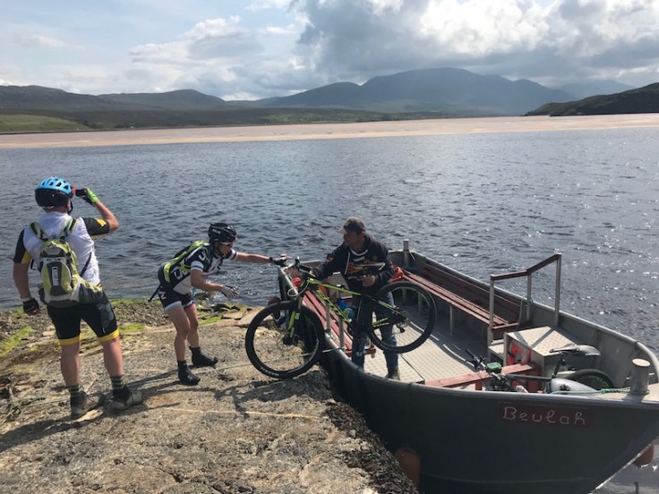
At one point as we crossed the Kyle we all had to reposition ourselves in the small boat to prevent it from grounding, such was the low level of the water…
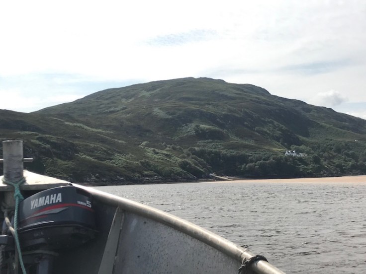
… but we safely arrived on the other side where we met more passengers returning from their morning’s visit.
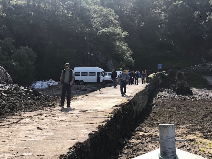
Two of our number announced they were going to walk rather than catch the minibus which I was worried would put the trip in jeopardy but the driver was kind enough to take just the four of us and we set off for the hour’s journey at 15 mph.

It’s an amazing track to ride along.

Not the most comfortable of journeys but the fascination of the scenery makes up for that, as does the commentary and explanations provided by the driver as the route progresses.

It passes evidence of the army’s use of the area including where the barrier comes down to prevent access and accommodation for those doing the training and manoeuvres…

… and their vehicles.

Luckily it was all quiet the day I visited and the track was open.
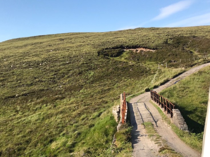
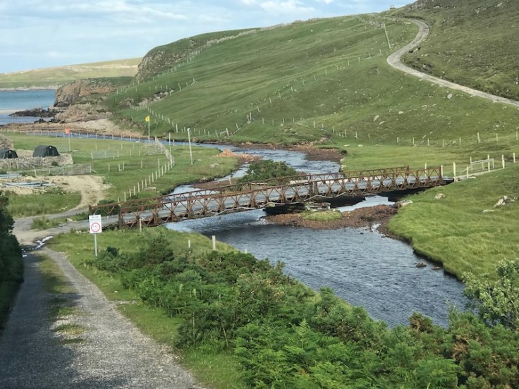
There are a number of challenging narrow bridges for the minibus to pass over, some of which have been installed in more recent times by the army as part of their exercises.
Sections of the track include some steep inclines while others are for miles without much steering effort required.

Stuart, one of the regular drivers on the route, pointed out many aspects of the scenery as the journey continued including small craters as a result of bombing exercises making you realise how important that barrier is to prevent access when needed.

But perhaps the scariest part comes after ten miles where the track is carved out of the valley side incoporating a sharp drop to the nearside along with a soft verge. This section is called the ‘Wall of Death’ but Stuart’s driving skills made it look easy, although I wouldn’t like to try it.

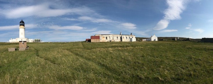
Just a mile further on from that, Cape Wrath and its famous lighthouse comes into view…

… and the terminus of the route.

It truly is Britain’s remotest bus terminus, and of course, the most northerly point on mainland Britain – even beating John O’Groats. But if you were expecting it to be deserted, you’d be wrong.
Although the lighthouse was automated back in 1998, John and his daughter still live in the rather ramshakle accommodation here.
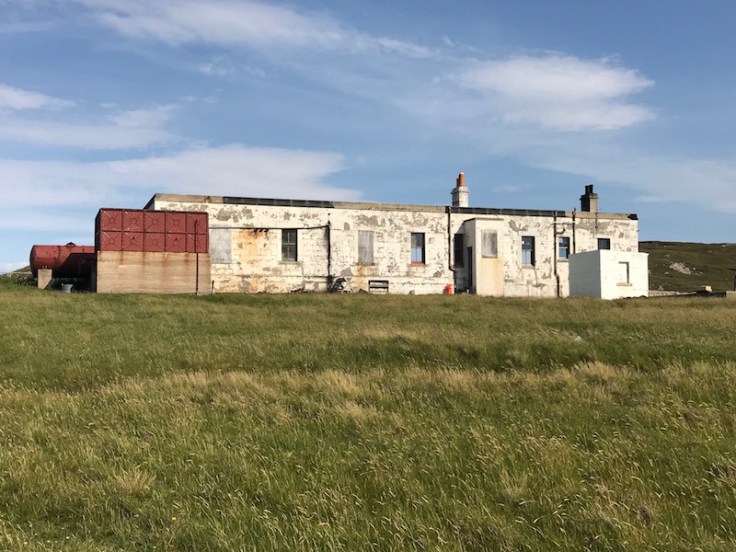
Not only that, they run the Ozone café serving refreshments and souvenirs for visitors arriving on the bus, or even those who walk the eleven miles.
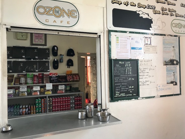
As I wrote back in 2019, you have to marvel at the logistics they surmount, having no mains water, gas, electricity or sewage connections, nor mobile phone signal yet run a commercial business reliant on the small number of tourists who make the journey and then buy something!

I’ve come across a few surprises on my travels over the last decade or so but this remarkable café truly was the most unusual thing I’ve ever seen. Supplies, including water, come from Durness once a week where any post is also kept for John and his daughter. Rainwater is harvested for the toilet and washing – there’s a notice in the bathroom to use sparingly!
We’d passed John’s daughter about four miles from the jetty along the track, where she can just pick up a mobile signal, so was spending the afternoon online shopping on the back seat of her car!

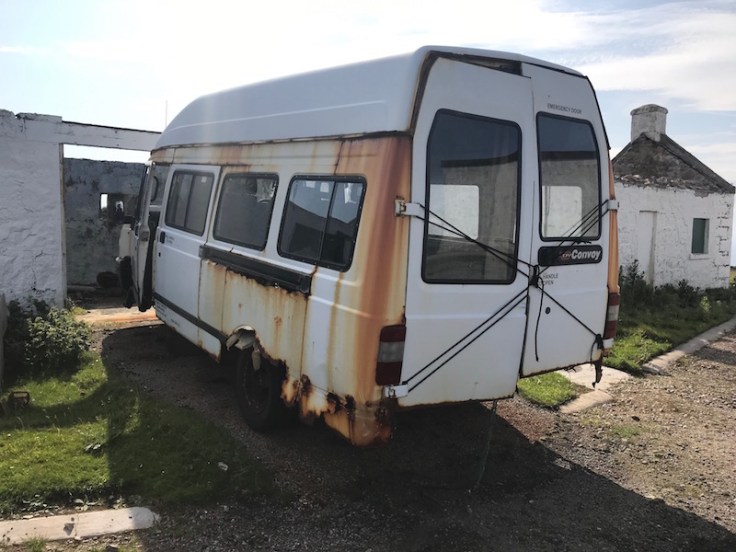
Around the lighthouse there are abandoned vehicles including John’s minibus which was awaiting a part when I visited. It looked as though it had been a long wait.
And the views are magnificent – out into the North Atlantic – and all so quiet and peaceful.

Luckily it was a lovely sunny day too as it wouldn’t be much fun here with the Shipping Forecast often predicting Storm Force 10 gales.
After an hour’s ‘layover’ it was time to get back on the minibus for the return journey back down the track to West Ferry Point for the ferry back across the Kyle of Durness.
It had been one of the most memorable bus journeys ever.
And definitely deserving of being awarded the accolade of Britain’s Second Most Quirkiest Bus Route.
But what could possibly be the top quirkiest bus route to beat even that?
All will be revealed next month, on Saturday 22nd November.
Roger French
Did you catch the previously featured Top 10 Quirky Bus Routes? 10: White Bus route 01, 9: Borders Buses route 477, 8: TfL/Transport UK route 969, 7: Tavistock Country Bus route 112, 6: Royal Parks route RP1, 5: Cumbria Classic Coaches route 572, 4: Stephensons route 14, 3 Imberbus route 23A.
Blogging timetable: 06:00 TThS

What a wonderful experience and an amazing bus journey.
LikeLike
I thought Dunnet Head is the most northerly point in mainland Britain?
LikeLike
What’s the fare?
LikeLike
In 2019 the ferry was £7.50 and the minibus £13 (both returns).
LikeLiked by 1 person
The Web site shows £20 for 2025 Return or £15 Single
LikeLiked by 1 person
We travelled on this some years before you, when the lighthouse was still functioning, and of course no café then. My travelling companion had tried to do it twice in the past, but one time the wind was too high and the other time the ferryman was at the local highland games, so nothing was running. I had travelled from Inverness on Stagecoach route 25, long since superceeded, whilst my friend joined me at Durness, having driven there.
We had the same problem as you with too low tide, so had ages to wait. The ferryman occasionally came to check the water, and eventually just as it started tipping it down, we got taken across, getting soaked in the process. There were two minibuses running that day, but there were only the two of us for the waiting one. No minimum numbers in those days thankfully. I recall we passed a walker drenched by the rain, albeit it had now ceased. The minibus driver lent him some waterproofs, and said just leave them at the ferry. Luckily we had a dry and sunny fantastic journey to Cape Wrath, although the speed and going round blind bends flat out (because he knew there would be no other vehicles) were rather terrifying. We expected to return on the same bus after a short break, but the people from the previous trip were needing to return (must have been there hours). Our driver, John said he would be back for us in 45 mins. Confused by this, as the journey took longer than that one way, he explained he would meet the other bus en route, and swap the passengers, saying that the other driver was 86 years old, and needs to finish early to get home for his tea. He pointed out that there were 41 places along the route where they could pass each other, but only a handful where they could turn round. Communication with the other driver was by walkie talkie radio, as mobile phones did not work there.
After a great time spent wandering around. John arrived back as promised. However, accending a steep hill, omnious noises were heard coming from under the minibus, and something went bang. The driver inspected under the bus and concluded the Hardy Spicer (whatever that is) had broken, and we were stranded there. He tried contacting the other driver on the radio, but got no reply, nor from the ferryman. So he resorted to try to call any passing fishing boats, but again nothing. We were in the middle of nowhere, so maybe even the radio was not working. He decided the only course of action was to push the bus to the side of the road and walk back the several miles to the lighthouse. My friend went with him, leaving me alone on the bus. Seems I missed out on tea and biscuits at the lighthouse, but the hills would have been too much for me to join them.
A couple of hours later I was rescued by the lighthouse keeper in his land rover. But the fun was not yet over. Once there was a radio signal, the bus driver managed to contact thr ferryman, but by now he had spent a good few hours in the Cape Wrath Hotel, and was extreemly inebriated. He managed to get the boat over to us (thankfully the tide was still high enough), but the bus driver thought it safer if he steered the boat!
We had enjoyed the trip so much that we went back and did it again the following day. This time busier and uneventful, our avandoned minibus still parked by the side of the road. This time it was a lady driver, much slowe than John had been, but at least we got to see the scenery on the way back, the land rover had no side windows, so we saw next to nothing the precious evening. I find it hard to believe this route can be beaten, so looking forward to next week’s revelation of your No1 rpute.
LikeLiked by 3 people
What an amazing experience you had – thanks so much for sharing.
LikeLike
Various types of “Hardy Spicer” (manufacturer name) joints exist , some with rubber sandwich couplings effectively , they are normally one or more joints on the propshaft with one on the output of the gearbox and one attached to the rear axle ( crown wheel drive ) sometimes there is another in the middle of a split propshaft. while a totally solid connection can be done it is subject to stress and movement particulary as the rear axle on its springs moves up and down relative to a fixed gearbox. They do wear (I have changed mine on a couple of cars in the past) , some can be greased to increase life and that is a maintenance task not always done.
JBC Prestatyn
LikeLike
LDV Sherpa vans as minibuses !!
I’m amazed they have survived, nevermind that parts are available.
LikeLike
It seems that they don’t still use these old LDV Convoy minibuses any more.
Their website has been updated since 2019, and now says that they use two Ford Transit minibuses 15/16 seats, and both pictures of their LDVs I found online are listed as SORN by the DVLA.
Parts for LDV Convoys wouldn’t be too much of an issue, as the entire LDV company and assets were acquired by a Chinese company in 2009 who now sell the replacement products in the UK and other markets as ‘Maxus’ (LDV name was used until 2020?). Well all their products are Battery-Electric now, at least the new ones in London are.
LikeLike
This must be one of Britain’s remotest bus services as well as being one of the quirkyest.
John Stokes
LikeLiked by 1 person
A wonderful tale Roger. There are indeed many tremendous public transport journeys in the UK for those who are prepared to make a little effort.
So much more rewarding than a view of the world from behind a car windscreen.
LikeLiked by 2 people
£13? No wonder some decided to walk. 😉
LikeLike
Worth every penny ! You would need to pay me an awful lot more than £13 to even consider walking it !
LikeLiked by 1 person
£20 now
LikeLike
For quirkiness, I could suggest the bus service on Sark, although whether that counts as Britain depends on your definition.
Another is the route which links Gibraltar airport with the town. It uses a level crossing… across the airport runway.
One which is not British at all, but definitely quirky, is a local bus route which operates in three nations. Liechtenstein Bus has a route where neither terminus is in Liechtenstein – it extends out to Feldkirch (Austria) at one end and Sargans (Switzerland) at the other.
Looking forward to seeing what is crowned Britain’s quirkiness bus route!
Malc M
LikeLiked by 1 person
Cape Wrath is 58.6255’North while Dunnet Head is 58.6726’ North (so the internet says). When I went to Dunnet Head however there was no bus beyond Dunnet village. Dunnet Head is however the most northerly point on Great Britain?
LikeLiked by 1 person
This reminds me of a newspaper article I read years ago concerning the very opposite part of the island of Great Britain – Lands End (or is it Land’s End?). The article claimed that a new survey had discovered that the westernmost spot was not Land’s End at all but nearby Cape Cornwall, which was 1.488 metres further west. But the date was 1/4/88 – it was an April Fool!
V ….. Saltash
LikeLiked by 1 person
In fact, Cape Cornwall had previously been considered to be England’s most westerly point, but accurate surveying found that it is Lands End.
LikeLike
Cape Cornwall wins it for me, on the simple basis that it’s naturally undeveloped, unlike the ‘theme park at Lands End.
LikeLike
Roger
I am reminded that a group of us took former Brighton, Hove and District Lodekka KPM 91E – by then an open-topper – as far as the mainland ferry slip in 1983 where there was disappointment that we clearly would not get it to Cape Wrath. Of all vehicles, a new Maidstone and District Leopard was in that area too.
Next day, however, we managed the other corner – Dunnet Head and John o Groats.
Sholto Thomas
LikeLiked by 1 person
That’s amazing! Thanks.
LikeLike
Oh dear, we are getting into the definitions of Britain and Great Britain. I imagine most readers would put the Isle of Wight, Ynys Mon and the Hebrides in Britain and/or Great Britain; it follows that Orkney and Shetland and Fair Isle are too. So Dunnet Head is not the most northerly point in Great Britain (that’s on Fair Isle), but it is the most northerly point of mainland Britain.
Ian McNeil
LikeLike
I think Great Britain is a geographical term to describe the largest (hence “Great”) Island comprising of England, Scotland and Wales, any other islands are part of the British Isles.
Peter Brown
LikeLike
I guess the Ordnance Survey should know the correct answer to this question, and they say:-
“Great Britain is the official collective name of of England, Scotland and Wales and their associated islands.”
https://www.ordnancesurvey.co.uk/blog/whats-the-difference-between-uk-britain-and-british-isles
RC169
LikeLike
Great Britain cover England Wales and Scotland
The United Kingdom adds in Norther Island and some of the islands but nor the Crown dependencies
LikeLike
I was there in the 1980s with a group when the ferry existed(as today) then chartered a minibus for the spectacular ride . The only rooms were in a former army barracks. Gerald D.
LikeLike
Following on from the message above where the bus broke down on the journey back, I was the friend who walked back with the driver to the lighthouse to get some help. I remember the driver saying that I would have to wait outside as the keepers never ever invited anyone into the lighthouse.
But we were both invited in and provided with tea and cake and had a lovely chat while they decided who was going to drive us back to the ferry. What I was surprised about was that the three keepers (always three at a manned lighthouse) were all totally different characters yet they seem to get on so well together.
We then drove back, picking up Brian en route and the story continues as mentioned above. I still remember this wonderful experience so clearly.
Lawrie
LikeLiked by 2 people
Many thanks for adding this memory to complete the story of that amazing experience.
LikeLike
Ian McNeil – no, Fair Isle is mid way between Orkney and Shetland, the most northerly point in Great Britain / the British Isles being Out Stack, off the island of Unst (which was the scene of Roger’s most northerly bus stop)
LikeLike
You’re right, of course – how I confused Fair Isle and Faeroes is beyond me.
Ian McNeil
LikeLike
Well they do sound similar. But if you’re implying that the Faeroe Islands are part of Great Britain / the British Isles I think you’re wrong there too!
LikeLike
Just to clear this up: my reference to Faeroe was to its location which I mistakenly thought was Fair Isle, not its nationality. What I was trying to say (and I apologise for the inaccuracy) has been professionally expressed in the OS quote (Anonymous at 9:48pm).
Ian McNeil
LikeLike
I was lucky enough to do this in 2017. A great day out, and indeed very quirky! Rob F
LikeLiked by 1 person
As i said a few weeks ago, one quirky route on Wirral is the 129 Liscard-Frankby Cemetery, it only runs on a Sunday with one journey each way, & has been running since the 1950s, & the launch of the route caused a dispute between Wallasey Corporation & Crosville as to who was going to run, & keep the profits from the service.
SM
LikeLiked by 1 person
Thanks; it’s on my radar.
LikeLike
I assume there might be a summary of “runners up” before the number 1 is revealed
JBC Prestatyn
LikeLike
Thanks for sharing Roger, some lovely photos.
I was up in that area in the 1970s but was unlucky as it was closed due to MOD activity, and I’ve not managed to get back – yet!
My guess for number one would be the bus service on the Scilly Isles between the airport and the town, once run with a Leyland National I believe.
Richard Warwick
LikeLiked by 1 person
There’s also the St Mary’s circular bus service which is run with a minibus – I took a ride part way round and walked back to Hugh Town
LikeLike
Ian McNeil – I was using the term Great Britain correctly ie the island of Great Britain which is the largest of the British Isles. Most northerly point in the British Isles is clearly some way north of Great Britain (the Island).
LikeLike
I can’t believe there’s going to be an even quirkier route than this one!
Steven Saunders
LikeLiked by 1 person
Is (for example) Muckle Flugga in the UK? Yes
The UK is the United Kingdom of Great Britain and Northern Ireland.
Is Muckle Flugga in Northern Ireland? No
So it is in Great Britain, which therefore (as The OS says) comprises the mainland of Britain and its islands.
LikeLike
Every time I read your quirky bus routes, Roger, I put them on my ‘must-do’ list but on this occasion I don’t have to as I did this one a few years ago. I remember waiting on the quayside and we all laughed with disbelief when a lady pointed out our transport as the tiny boat moored in the Kyle. She was, of course, proved correct. Another oddity I remember was seeing the twice-weekly Durness Bus to Thurso with a trailer for all the passengers shopping. As you state, an incredible journey in a remote part of Britain. Can’t wait to find out what your No.1 is and how it can surpass this one..
Barry Davis
Bromley
LikeLiked by 1 person
Many thanks for sharing this wonderful experience, Barry.
LikeLike
Considering that it is MoD land near Cape Wrath I am astonished that there is no connection from the track directly to the A838 south of the Kyle of Durness. I understand that a lot of road building in Scotland after the Union was done for military reasons.
LikeLike
I’m struggling to believe that there is something more quirky than this! If it wasn’t no. 1 before, do the comments at 4.23pm and 10.23pm warrant a reclassification!
LikeLike
No, that’s not precisely correct – please see the comment above at October 11, 2025 at 9:48 pm, citing the Ordnance Survey.
It is correct to say that the Crown Dependencies are not part of the UK – their status is explained here:-
https://www.royal.uk/crown-dependencies
The Scottish islands are part of Scotland, and therefore also part of Great Britain. Similarly for the English and Welsh islands
Nigel Frampton
LikeLike
The above comment is in response to the anonymous comment at October 13, 2025 at 6:44 am.
For some reason the linking was lost.
Nigel Frampton
LikeLike
Hooray! One on the list I have ridden on!
LikeLiked by 1 person
A greatrip which I did a few years ago with a party of 15, several bus trips involved to ferry us all.
LikeLike