Sunday 17th August 2025
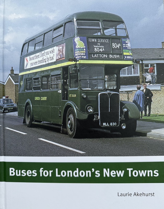
The third review in this weekly trilogy of recently purchased books is a must read for anyone interested in the minutia of how bus networks develop to serve an expanding New Town over a period of three decades.
Anyone who has devoured one of Laurie Akehurst’s previous books on London Transport Country Buses will not be surprised to know this latest recently published volume entitled ‘Buses for London’s New Towns’ maintains his track record for providing a blow by blow detailed account in chronological order of changes introduced to bus routes in a defined area.
As its name implies this book’s defined areas are the six New Towns that fell inside London Transport’s Country Bus Area that, along with others elsewhere in Britain, were designated New Towns in the New Towns Act of 1946.
They are Crawley, Hemel Hempstead, Stevenage and Harlow with Hatfield and neighbouring Welwyn Garden City, which Laurie sensibly treats as one continuous area, added in 1948.
It was envisaged each New Town would grow from an average of around 10,000 (pre expansion, Harlow was the smallest at 4,500 and Hemel Hempstead the largest at around 20,000) to 60,000 or more by the 1960s with the first New Town residents arriving in the late 1940s/early 1950s.

The book is in two parts with each New Town given two chapters (one in each part). The first covers route developments in the London Transport era between the late 1940s and 1969 and the second covers the shorter London Country period between 1970 and 1977 when the book’s timeline ends. That’s when each location had a new network of bus routes marketed with local branding and a prefix letter for the town routes.
I always admire Laurie’s ability to describe changes to bus routes in a narrative and readable format rather than just present list after list in date order. It enables him to contextualise the changes to what else may have been happening at the time, but I have to admit I do skim read over some of the detail where my knowledge of local landmarks and road names is lacking.
However, the book holds a particular fascination for me as a north London child and teenager during much of the period covered which often involved trips out to the Hertfordshire countryside and the areas covered by this book. Furthermore my parental home moved to Hemel Hempstead in the early 1970s so although I’d ‘left home’ by then for university, frequent visits and holiday periods from studying meant I got to know the town’s route network well so paid close attention to that chapter.
Similarly in later years after moving to Brighton I got to know Crawley well and found the history of that town’s network very interesting to read not least the handover of routes from Southdown to London Transport as the network developed to serve the increasing population.
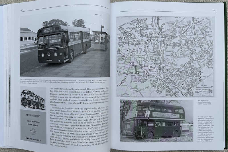
What I also very much like about this book are the excellent photographs and the many network maps from different years for each town which graphically show how the networks of bus routes developed.
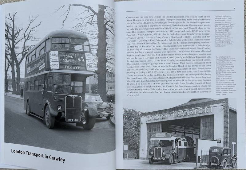
Obviously the early photographs are in black and white with ones in part two in colour and they feature renowned photographers of the time including Alan B Cross and Peter Mitchell (he of ‘Served by Southdown’ fame) and mostly in part two by Mike Harris who has the most amazing collection of superb photographs he’s taken over the decades.
Supplementing Laurie’s comprehensive narrative you’ll enjoy 214 excellent photographs within the 192 page book and as well as the aforementioned maps there are many images of leaflets and publicity items including a short appendix of timetable panels from bus stops too.
Laurie explains how some of the New Towns developed new infrastructure including bus stations and bus garages. Hatfield, Stevenage and Harlow all gained new garages in 1959 (Hatfield and Stevenage) and 1963 (Harlow).
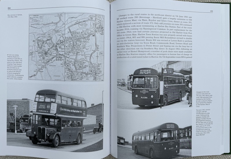
Hatfield’s replaced an old garage on the opposite side of the Great North Road with Stevenage replacing a garage in Hitchin and Harlow replacing one in Epping. Harlow’s garage still survives today and is owned and used by Arriva.
Interestingly Crawley had to wait until after the period covered by the book, in 1982, before gaining a new bus garage to replace the one opened in 1929 by East Surrey Traction Company. In 1948 just 13 vehicles ran out of the garage.
Hemel Hempstead’s bus garage at Two Waters also survived throughout the period covered by the book. In 1949 it had a Peak Vehicle Requirement of 46 which despite the growth in the town had only increased to 56 by 1962.
Notable developments covered by the book include the development of complex networks as residential areas expanded along with the introduction of driver only operation and the troublesome Merlin buses with their Autofare system of fare collection already discussed in ‘The London Merlins’ book review.
These new complex networks under constant development and expansion also saw a proliferation of route numbers denoting both new town routes and separate routes to serve industrial areas in these towns. A new series of 8xx route numbers was introduced simply because the 3xx and 4xx series were becoming used up. But in those days London Transoort loved its suffix letters to denote route variations and these proliferated in the New Towns.
But, as mentioned earlier, by the mid to late 1970s new networks based on a prefix letter – C (and C-line as a brand) in Crawley, H for Hemel Hempstead, G for Welwyn Garden City, T for Harlow and SB for Stevenage.
The SB concept came out of Superbus which was the high profile branding and flat fare arrangement introduced initially on just one route (809 Chells to the town centre) in 1971 and was an immediate hit with passengers.

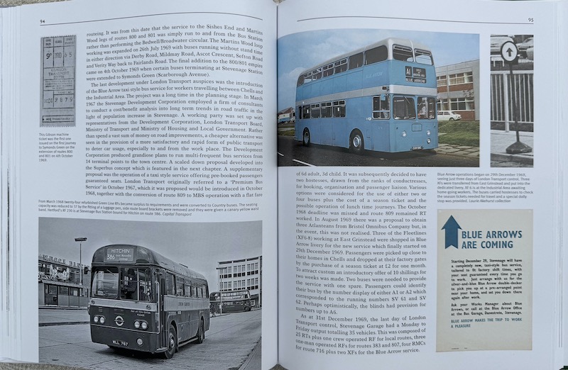
Two years earlier in the dying days of London Transport’s control of Country Buses in December 1969 the revolutionary Blue Arrow service had begun in Stevenage to encourage workers in the industrial area of the town to use the bus and have a guaranteed seat, taxi bus style with a hostess on board too.
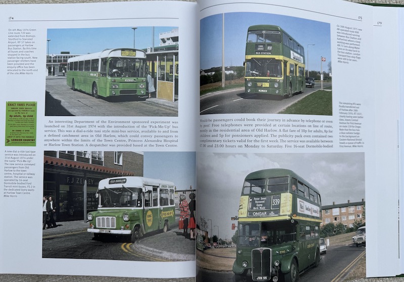
Another notable development in Harlow in 1974 was the Pick-Me-Up service, the forerunner of today’s DRT.
The 1950s to 1970s is a fascinating 30 year period to cover, all the more so as these six New Towns expanded. I looked up the current populations in each town with Crawley topping the list on 115,393 followed by Hatfield and Welwyn Garden City on 101,175. The other three are virtually the same with Stevenage on 89,023, Harlow on 88,958 and Hemel Hempstead on 85,629.
There’s no doubting which town of the six featured has the best bus network today – thanks partly to the proximity of Gatwick Airport. It would have been inconceivable back in 1948 that Crawley would develop in the way it has and how ironic that whereas Southdown ceded the territory in the 1960s to London Transport, today the town’s extensive and much admired network is run by the same company as manages Brighton and a significant part of Sussex.
More recent developments in the other five locations – the rise of uno, Central Connect and the ‘Red Group’ – are equally interesting to note.
In that context Laurie’s book records a fascinating period in history.
It was published by Capital Transport last year but is still available from all the usual outlets with a cover price of £35.
Roger French
Summer blogging timetable: 06:00 TThSSu

The most notable thing to notice in nearly all those towns is the very sad decline of the services
LikeLike
The network around Welwyn / Hatfield is better than its been for ages, although the combination of commuting to the University and the BSIP improvements means the focus is very much on longer distance rather than town services. But I wouldn’t disagree with you over the Hemel network, which is in a sad state.
LikeLike
In the case of Crawley, the Borough Council , assiduously support bus services in and around the town. We have recently seen a fleet of hydrogen fuelled vehicles added to the fleet.
LikeLike
Harlow’s town services are especially in a sad state now. Today, being Sunday, you’ll find a small number of routes running every 2 hours and that is it! Even in the week, the services are of variable frequency from every 20 minutes to hourly, not even close to turn up and go. The routes to Stansted and Epping/ North Weald are the only truly frequent routes, 7 days a week. Harlow seems quite isolated as far as buses are concerned, even with the 724 still around. Harlow used to be well connected with places in North East London like Chingford, Walthamstow and Romford. Such links need to come back.
Aaron
LikeLike
Interesting that Hemel Hempstead had a PVR of 56 in 1962. It’s less than that now and it covers the closed Tring and Garston( with a fleet of just under ) garages as well. That’s what 20+ years of Arriva achieves. I would have thought that UNO’s fleet at Hatfield is similar to the LT fleet at Hatfield and St Albans, now closed, so it’s not the area or the County but the operator that matters.
LikeLike
Towards the end of my secondary-school-era buying Weekender tickets was a joy: new networks to explore after being self-schooled on the Central Bus & Underground networks as a Twin Rover ticket holder. Living in Walton-on-Thames it was only natural visiting Stevenage as top priority on the first Saturday of my first Weekender ticket. I had seen 716 and 716A coaches depart for Hertfordshire from my hometown on many occasions – now was the time to do a visit. I did get to Stevenage several times, the latter occasions under LCBS as operator. I certainly got to Chells on a Superbus and rode an Autofare route in the Reigate & Redhill area. Hot summers of 1967 and 1968. One Sunday riding up to Stevenage I got thirsty aboard a 716 or 716A so popped down to speak to the conductor. I asked him if he knew where I could get a cup of tea in Stevenage that Sunday morning. On arrival at Stevenage, I was escorted into the Garage canteen. The complex nature of the 716 and 716A operations was such that there were two roads in Hertfordshire where one could catch a coach to London and Surrey from both sides of the road. The crewing arrangements for some Green Line coach routes was complex. A 716A from Woking to Stevenage would undergo two changeovers: at Addlestone and Hatfield. “Tango” crews would work: Addlestone & Woking or Hatfield & Stevenage shuttles with other crews working between Hatfield and Addlestone. Between Luton and Crawley on Route 727 there would also have been two driver changes: St Albans and Reigate. Supplementary waybills aplenty so that Inspectors could undertake ticket checks correctly. Almex-A ticket machines spread from the 724 and 727 to other routes which went OPO. It had an audit roll so that the details of each ticket could be recorded. A Setright merely totalled a conductor’s ticket sales for his duty. I would have ridden Addlestone Garage RLHs but the peculiarity of this joyrider is that I more closely associate this class of bus with East End rides on Route 178.
LikeLiked by 3 people
Google ‘AI Overview’ list eight ‘London New Towns’ – the six in this book plus Basildon and Bracknell. That still leaves ‘south of London with only two – I wonder why the imbalance, Boxing the compass, that is N – 3, NE -1, E – 1. SE – 0, S – 1, SW – 1, W – 0, NW – 1.
LikeLike
At a basic level I suspect the Weald & Downs means much of Surrey, Sussex and Kent were less suited topographically to such sizeable developments due to the hills (Crawley is squeezed on a flat bit between the North & South Downs alongside an airport) and the flat bit of North Kent already being well developed.
A slightly cynical take may also suggest that the residents of those south of Thames counties, or parts of that were the right distance, may have been less inclined to accept them and may well have been in a position to influence, historically London commuters would often live in areas related to proximity of central London offices to specific railway terminals which would suggest many civil servants working in Westminster would be coming from south of Thames locations (the City looked east, so North Kent & Essex plus parts neighbouring counties whilst the West End looked west to Berkshire, Bucks, West Herts & Hampshire & West Surrey). So north of Thames residents were more weighted to business & finance sectors.
Dwarfer
LikeLike
My uncle and cousins lived in Crawley so I did a lot of bus spotting there in the 70s and remember the launch of the C-Line network which drivers immediately rebranded by adding a D in front !
My visits to Stevenage, Hatfield and Welwyn Garden City were always courtesy of the 0815 ish departure of Green Line 724 from Staines alighting at The Cherry Tree at Welwyn thence a 303 to Stevenage. For some reason I rarely visited Harlow. Perhaps too far to travel even as a teenager then.
Hemel Hempstead in the 70s was interesting as it had quite a few RTs running on town routes as well as the trunk route 301 allowing visits to Tring.
That book is a must for me. Thanks for the trip down Memory Lane Roger
Dominic W
LikeLiked by 2 people
A great book indeed and a reminder that the Development Corporations and Bus Operators worked close together in planning public transport in such areas. It was great being with Country Buses & Coaches that time.
Tony Francis
LikeLiked by 1 person
The original London Country Bus Garages. Not many of them left now
Addlestone (WY)
Amersham (MA)
Bishops Stortford (BS)
Chelsham (CM)
Crawley (CY)
Dartford (DT)
Dorking (DS)
Dunton Green (DG)
East Grinstead (EG)
Epping (EP)
Garston (GR)
Godstone (GD)
Grays (GY)— Argent Street (GA)
Guildford (GF)
Harlow (HA)Hatfield (HF)
Hemel Hempstead (HH)
Hertford (HG)
High Wycombe (HE)
Hitchin (HN)
Leatherhead (LH)
Luton (LS)
Northfleet (NF)
Reigate (RG)
Romford London Rd (RE)–North St (RF)
St.Albans (SA)
Staines (ST)
Stevenage (SV)
Swanley (SJ)
Tring (TG)
Tunbridge Wells (TW)
Ware Park Road (WE)–Town Hall (WA)
Watford High Street (WA)–Leavesden Rd (WT)
Windsor (WC)(WR)
LikeLike
Tony Francis suggests close working between New Town planners and Bus Service planners , however I dont think that was in reality happening efficiently. Compared to Germany where the needed rebuild of existing towns brought the likes of Baden Baden and Dresden with some building with Tram and Trolleybus networks retained the motor bus of England had to contend with local (new) roads still aimed at the motor car.
Crawley might be a South of London exception on new town creation but one reason for the the new towns was a fear of a cold war / invasion and Kent and Sussex in theory first in the firing line, also supposedly Nuclear Strikes on Central London would still allow places like Hatfield to function (this was 1950s thinking pre the super computer or anything else) Some Planning still had the motorway box routes around London behind it with the A414 of today effectively linking towns New – and Old – across the Northern Arc of the South East Economic Boom areas from Watford to Basildon.
South Londonders were being encouraged by the 1960s to move out – Crawley was one location , Hemel Hempstead and expanding East Grinstead others (Bracknall was the Big one for folk from Fulham ) Rather Ironic as my reasearches showed these were the places their ancestors had come by carrier cart or early railway to work in the expanding London of it Suburban Era of Tram Track development and then LCC new estates.
South of London the likes of Guildford were expanding with its Park Barn and similar estates and thus population growth was bolt on to existing towns rather than totally new school and workplace locations, my London Uncle had moved to Weybridge with the growth of the techno parks there.
Hemel Hempstead like many of the northern new towns was created away from its railway station with no thought of making an easyway back to London for Commuting – the towns had to work for themselves was the idea – and the low increase in PVR was essentially the growth in the new build bit was fairly efficient to connect to the town center and main work areas at Buncefield, Kodak and the Paper companies with shift starts for the factory at one time and office workers an hour later. Tring was still open to take the Green Line Service increases as needed. Biggest issue with HH was effectively it was Cricklewood north.
Stevenage managed to have its fairly swift – but not cheap – Kings Cross connection but the new houses wouldnt attract the stockbroker classes and the Furniture Making of inner north london had burnt away in WW2. Interestingly a few of the new towns had their own Green Belt places it seemed and were not connected as well to adjoining towns to the north – the likes of Redbourn for Hemel Hempstead now with a few bus services in the day and the fields and farms still predominate the land not eaten by Motorways
Harlow was meant to have the M11 running up the west side having the industry and warehousing planned for that side , the switch of it to the east ended up with it being the wrong way round
Hatfield – Welwyn Garden City had already grown with the likes of Aircraft design and build and my other east london uncle moved to Hatfield (the final one going to Basildon)
Again more mini town growth in Waltham Abbey and Luton’s newer suburbs.
Back to South of the Thames and the unplanned – yet maybe better for it – and the Coming of Ebbsfleet as a Dartford – itself expanded after WW2 – overspill.
The final New Town for London of course was in London – Thamesmead – where no special buses, no thought to connect in an advertised way to rail – and Tube long promise but undelivered – and a lack of community services too, yet folk like living there for all the faults.
JBC Prestatyn
LikeLiked by 1 person
I remember reading in Buses Magazine back in the 80s about a startup operator called Welling Hatfield Line using those futuristic looking Optare City Pacers.
Regarding urban planning and New Towns, Milton Keynes was totally car orientated with its grid roads and roundabouts, with cul-de-sac estates located off the main grid. This made for very difficult bus operation. I noted yesterday in an article that the MK Metro name could reappear in a new “mass rapid transit” scheme (awful Americanism beloved of the media and politicians). Promising deficsted lanes (we’ll see post “war on motorists” backlash).
https://www.miltonkeynes.co.uk/news/people/roads-designated-for-tram-like-vehicles-and-more-signalised-roundabouts-this-will-be-milton-keynes-in-2050-5270467
Peter Brown
LikeLike
I dont know that Milton Keynes was ever motorist friendly. Grid system maybe but roundabouts give a lurching ride, particulary on diverted off M1 Megabuses when upstairs and NatEx trying to find the Coachway.
Northampton also grew eating up villages in a way my mental mind wont map properly and Kettering and Corby are now the growth areas with the A14/A45 pushing Port to Big Box Warehouses 44tonne lorry routes.
Some thought that local govt reorganisation will save all our woes with Surrey being cleaved in various permutations. The best seems to be a West Surrey – with Guildford or Farnham competing to have leadership leaving Woking and Esher as outliers be tower block central with 35mins to Waterloo Expresses or leafy gated houses for the football and media rich respectively
East Surrey could gain Crawley , possibly finally with Epsom , Ewell and Banstead moving to a new London Borough , which I think would make sense with health service provision and a more logical oyster zones to the rail network ends.
As to the New Towns the routes were launched with RTs mainly , was there enough demand for RML space ? If London Country had been created a decade earlier I could imagine something like the Devon General Atlanteans and Fleetlines being used instead – which would have suited Hemel and Harlow
JBC Prestatyn
LikeLike
‘possibly finally with Epsom , Ewell and Banstead moving to a new London Borough’.
If only this would happen, about time Greater London as a whole meant any town in the continuous built up area. That would mean much of southern Hertfordshire, towns in Epping Forest District, Epsom as you quite rightly mention, Staines/ Spelthorne for sure and places like Dartford and Grays. All places either served by red buses now or were historically. The New Towns mentioned in the blog have strong ties to London but for the most part have strong local employment, which was always the plan. My town of Cheshunt and others like it, are more or less dormitory suburbs dominated by commuting to London, a stark contrast compared to the efforts made to ensure people lived and worked in the New Towns.
So far the government is denying any changes to any county boundaries as part of reorganisation, which is a mistake. And one I don’t think can last, London’s devolution is looking quite dated all of a sudden and suddenly we have Tories in places like Havering that want to rejoin Essex. Will be interesting to follow in coming years I think.
Aaron
LikeLike
@Aaron – when Greater London came into being in 1965, it was to include the borough of Epsom & Ewell. Epsom & Ewell was only removed from the plans at a late stage (as legislation passed through the House of Lords).
Other places which had originally been planned to become part of Greater London, and had been removed earlier in the process, included Caterham, Warlingham, Banstead, Esher, Weybridge, Walton, Sunbury, Staines, Watford and Cheshunt.
I understand the reason these places were dropped from the plans was due to local pressure/opposition.
(source: London’s Boroughs at 50, Tony Travers)
Malc M
LikeLike
Yes I was aware of this, it may have made little sense for London to cover these areas 60 years ago but all those towns and London have expanded a fair bit since then and still growing, that to me it’s surely time to look at the boundaries again. None of the towns listed are distinguishable now.
Also I think some places were against joining Greater London but were forced into it regardless. I’m sure Barnet was one of those places.
Aaron
LikeLike
“Welling Hatfield Line” LOL! That would be Welwyn Hatfield Line, I think.
LikeLiked by 1 person
But I wouldn’t disagree with you over the Hemel network, which is in a sad state.
Interesting that Hemel Hempstead had a PVR of 56 in 1962. It’s less than that now and it covers the closed Tring and Garston( with a fleet of just under ) garages as well. That’s what 20+ years of Arriva achieves.
It is important to note that Crawley, in particular, has a decent Town Centre with Bus Station and Enquiry Office and printed timetables.
Harlow and Hemel Hempstead have unattractive Town Centres, with a bus station at Harlow and no printed timetables. In particular, Hemel Hempstead has a poor indoor shopping mall, with around 50% of shops empty. Harlow isn’t brilliant, with a dated town centre.
Frankly, there is little reason to visit either town for shopping or entertainment . . . in Hemel Hempstead shoppers visit out-of-town retail parks or Watford . . . both by car. It’s not just the fault of Arriva, although they must bear some blame.
LikeLike
I’m surprised the Tories – or even Reform – haven’t proposed a combined London and South East Assembly, as they will never win London again as it stands. After all, the former created the GLC when they couldn’t win the LCC anymore. It would have the additional advantage of prising out Khan!
LikeLike
Reform are looking at splitting the Outer London Boroughs from London and re-joining them with the home counties this though is very speculative sat present
Having such a set up would improved the coordination of bus services
LikeLike
@Anon 18/8 11:37 – how would moving the Greater London boundary improve co-ordination of bus services?
Would the outer boroughs retain the TfL-coordinated network, or would TfL shrink to cover only the inner boroughs?
If TfL no longer had responsibility for the outer boroughs, what would happen at the new London boundary?
In either case, how well-coordinated are the bus services outside the Greater London boundary?
Malc M
LikeLike
Were the New Town bus routes ever profitable? The curving roads, low housing density, and sparse off peak demand? Exiled Londoners must have felt betrayed by the service cuts in the 70s and 80s. But they’d probably all bought cars by then!
LikeLike
I was told once that there was a covenant on Harlow bus garage which prevented the land from being used for any other purpose. If true, that would explain Harlow garage’s survival, when so many other former London Country garages were sold off (either closed during London Country’s existence, or sold off post-privatisation – some might say “asset-stripping”!)
Malc M
LikeLike
Harlow Garage has far larger capacity then they need
LikeLike
Bromley is also muttering about (re) joining Kent.
I wonder if there is a strong case to split London in two – North – Renamed as Middlesex and South (Ideas welcome) with generally a split using the Thames – though perhaps after Wandsworth Bridge the SW and TW postcodes should fall into South with the Great West Road being the divide. I would move Heathrow completely into an enlarged Slough to stop Hillingdon moaning about the place.
The South East Planning Area (do they still exist?) covered effectively the bottom right hand square of the 3×3 map of england.
New Town Architecture I think is difficult to insulate and had low ceiling heights in the upstairs of the 3 bed semis – a feature of suburban London and elsewhere too but nearly all came with one or two garages on the housing plots and Essex Pargetting appears absent from much of the newer residential builds. Didnt concrete roads feature in Harlow ?
The red busness of the outside of London was a quirk of how London General expanded its services – were not even the Country areas run as London General painted in the Red Livery on the Single and Double Deck S class buses and similar ? If London General had not reached its sub “franchise” agreements with National for the north and East Surrey for the South that would have been a potential different breakdown of operation . National always seemed though to think that half hourly was a frequent service and seem frightened of entering London proper (I think it is related to geography) East Surrey saw Kingston, Sutton, Croydon and Bromley all as good places to send local routes into the Red Bus area matched by Generals Routes to Epsom and Dartford. ( Hersham/Esher was always an oddity of Red Bus dominance – and London United got to Molesey by Trolleybus ).
Did the new towns ever have powers to run their own buses – English Local Authorities are getting that in the Bus Services Bill ( but not those in Mayoral areas or London ones ? ) ( entire Bill/ Act worth a blog look ?? ) Even the older towns in the area had none – assuming Reading and Southend too far out for our consideration it was only Dartford that used Tram powers – but never ran Buses ? The non LCC areas of the GLC had lost their trams to the LPTB , but Ilford got its depot back when the trolleybuses ceased and I think is the only London Borough to run full sized Coaches for its School Services with a hire department for the use of schools and others for the likes of the swimming and sports trips out. Luton Corporation perhaps being the exception in the niche between United Counties to the North and London Country to the South. Thus few local coats of arms appeared on buses other than the “welfare” operations of towns and boroughs . Would the Harlow Dial-a-Ride (with its London twin of Hampstead on demand transport) count as local authority contract operation – was it funded by Harlow or by Essex ?
JBC Prestatyn
LikeLike
GoAhead East are revamping a lot of there services
An interesting new route is the 47 which will run from Bury St Edmunds to Braintree. The existing 89 which runs between Great Yeldham and Braintree will be cut back Great Yeldham to Halstead
LikeLike
Is that you, Bob?
LikeLike
The C prefix for Crawley routes, H at Hemel Hempstead, SB in Stevenage I can understand and G for the Garden City of Welwyn makes sense. But I can only think that the T for Harlow stood for Town, unless anyone knows better.
Steven Saunders
LikeLike
Steven,
Yes it did. When London Country relaunched the Harlow bus network in August 1980 the MAP name “TownBus” was initially used (and applied to buses), hence the “T” prefix. I’ve no doubt that this was reverse engineered to avoid having to use “H” as a prefix as this was already used in Hemel Hempstead.
LikeLiked by 2 people
Sadly, James Whiting has announced that he is retiring after 50 years of Capital Transport and there will be no new books after this year.
Andrew Vallance
LikeLiked by 1 person