
Thursday 13th February 2025

Blog reader Geoff kindly drew my attention to a recent online news story in which Derbyshire Live, part of the Reach news group, used a clickbait headline implying all was not well for “a new Derby bus hub”. It’s not yet been built and is linked to the huge residential development comprising 2,750 new homes south east of Derby, at Boulton Moor.
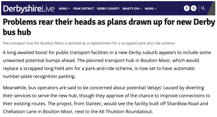
The report states not only will the “transport hub … replace a scrapped …. park and ride scheme” but also “bus operators are … concerned … by diverting their services to serve the new hub”.
Further on the report adds “planning documents submitted by the applicant claim that so far Arriva is said to have resisted diverting its route from Chellaston Lane to serve the transport hub ‘to avoid any unnecessary delay'” but also quotes an Arriva Midlands spokesperson denying this, saying: “as the leading bus operator in Derby, we’re wholly supportive of plans to improve the existing bus stops on Chellaston Lane immediately adjacent the proposed Boulton Moor District Centre. The proposal includes the provision of new bus shelters, real-time passenger information displays and a signalised pedestrian crossing – and they’re all things which help make our customers’ journeys easier. These bus stops are already well-served every 20 minutes by our 1B service, which was introduced through the first phase of the Boulton Moor development.”
So far from being “concerned” as the opening paragraph of the news report suggested, Arriva are in fact “wholly supportive”.
Similar confusion arises with the response from Trentbarton/Kinchbus.
Derbyshire Live reports: “the applicants claim other operators such as Trentbarton are also said to potentially feel diverting into the transport hub would cause ‘unncessary delays’ and prove ‘detrimental’ in favour of retaining their existing stopping points – 400 metres from the hub.”.
But again it quotes a spokesperson for Trentbarton/Kinchbus, which operates the Skylink service along Shardlow Road to the north of the site, saying: “We were briefed in 2021 on the proposal for a transport hub but have not subsequently expressed any opinion on potential variations to Skylink Derby’s route. We are always happy to talk to councils and other stakeholders about our routes.”
So far from being “concerned”, Trenrtbarton/Kinchbus are “always happy to talk”.
Reading the online report it comes over the applicant behind the Boulton Moor District Centre might, perhaps, be reluctant to provide a “transport hub” by suggesting bus operators aren’t interested in serving it, when it would seem they do, or at least are interested enough to discuss it.
Maybe there’s some confusion as to what the purpose of the “transport hub” is? The news report comments that 30 car parking spaces will be provided protected by ANPR cameras. Whether this is a hangover from the old idea of establishing a Park and Ride site, I’m not sure, but 30 spaces seems irrelevant to a transport hub.
As I was in Derby last weekend I decided to pop down to Boulton Moor and take a look at what this is all about.
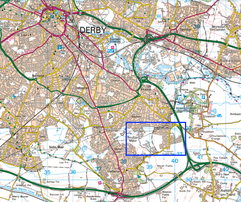
It’s located on the south eastern edge of Derby, west of the A6.
Boulton Moot has long been regarded as a “sustainable urban extension” of Derby being identified as such in the Local Plan by both the city and neighbouring South Derbyshire District Council, in whose area it lies.

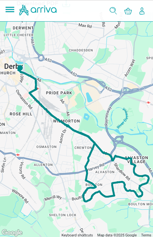
Phase 1 of the huge development, known as BM1, is pretty much complete, as you can see by comparing the images in the original planning documents, above, and the recent Google satellite image, below. Its associated District Centre (with the controversial “transport hub”) to the south of Shardlow Road and west of the A6/B5010 roundabout, has yet to be built as have later phases known as BM2, BM3 and an area known as The Triangle.

Arriva reorganised its well established routes (1, 1A and 1C) serving the Alvaston area (north of Boulton Moor) on 31st August last year with routes 1A/1C continuing as a circular and a new route 1B every 20 minutes serving the newly constructed BM1 area, known as Buttercup Leys, then continuing westwards to do a loop in part of Challaston in the bottom left hand corner of the above and below images (which is also served by route 2A every 10 minutes). Route 1B is being funded by developer Section 106 contributions.

As you can see in the above image, route 1B passes close by the location of the proposed “transport hub”, and as the Arriva spokesperson observed, there should be no problem serving it. Here’s an outline plan of what the developers envisage for the District Centre. I’ve highlighted the “Transport Mobility Hub” including its 30 parking spaces as well as e-scooter/e-bike parking.

Other buildings in the District Centre include a combined electric vehicle and petrol filling station, a medium sized foodstore, two restaurants with “drive thru” capability, local retail outlets, car club spaces, children’s nursery, care home, assisted living accommodation, community building and 400 new homes. Work is underway constructing these facilities in the south of the area as you can see in the photo below I took from a 1B passing by.

New bus shelters and information in the “transport hub” will be an improvement to what new residents currently have available. That being no shelters, and in some cases, no timetable information.

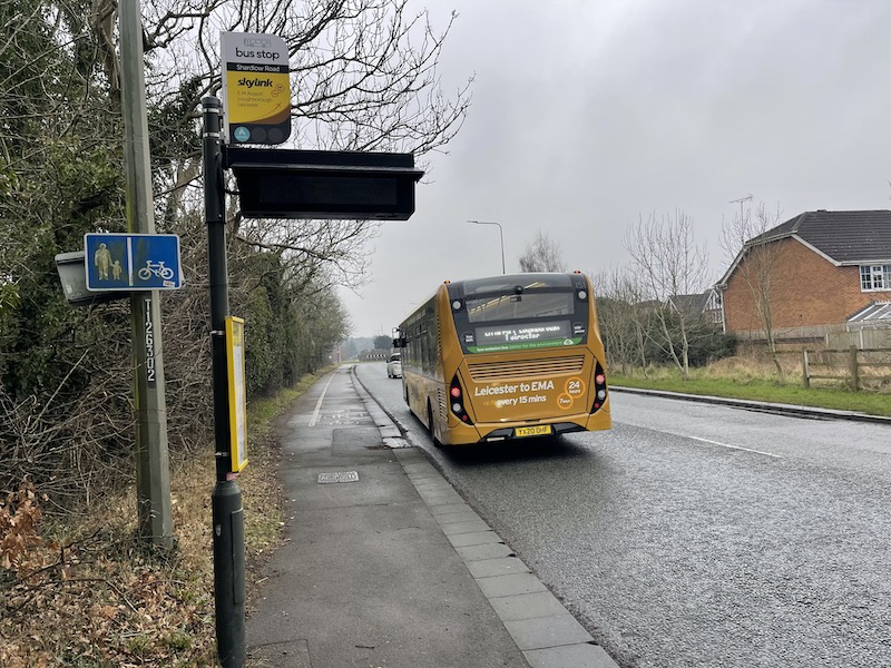
The bus stop I used in the newly served section of route 1B did have a timetable but there was no shelter and no hard standing from which to board and alight the bus. The bus stop flag and timetable case have been added to a lamppost. It was the only bus stop on the circular section of route shown in the earlier image alongside the number “1B”. Other bus stops on Chellaston Lane have no timetables on display – the images I took as we passed by aren’t very clear due to the weather, but you get the idea.

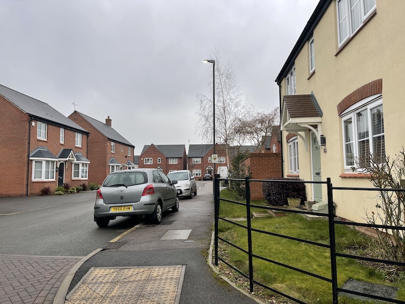
Walking around the original part of Boulton Moor, the omens for good bus use aren’t very encouraging with driveways dominated by parked cars.
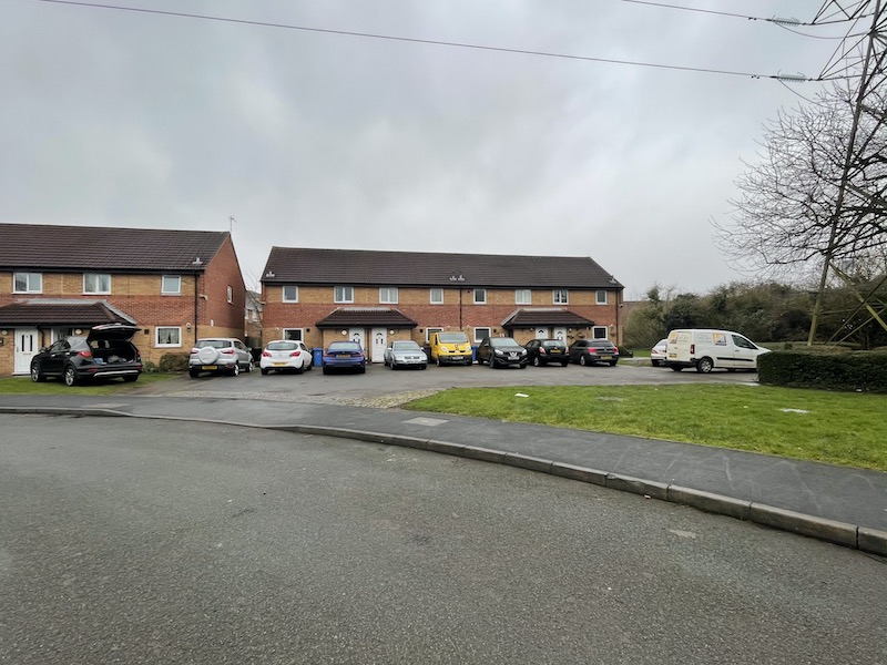
In the newer section now being served by the 1B there were less driveway spaces…

… but motorists always find a way of parking.
There’s some confusing information about where new route 1B actually goes. Arriva’s online map for routes 1A/1B/1C only shows the circular route of routes 1A/1C…
… and although the Derby network map shows the 1B it doesn’t show it continuing as far as Challaston which the timetable says it serves.
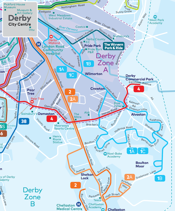
Trentbarton/Kinchbus’s Skylink (Derby-East Midlands Airport-Loughborough-Leicester) runs every 15 minutes along Shardlow Road with bus stops close to the junction with Chellaston Lane as shown on the earlier image in yellow. I can understand Trentbarton/Kinchbus keeping its powder dry’ on diverting into the “transport hub” as it will depend how easy it will be to slip into and out of it without being detrimental to a long inter-urban route.
But if Skylink buses are diverted into the “transport hub” together with Arriva’s 1B, potential passengers will have the choice of a frequent service into the city centre with the latter also offering longer distance travel opportunities.
But residents have got to get to the “transport hub” and some parts of the development are a long walk from a bus stop, as you can see from the earlier image and as I found on Saturday afternoon.
Let’s hope the developers plan for bus access into the District Centre before travel habits there are established as well as forthcoming developments in BM2 and BM3.

Roger French
Blogging timetable: 06:00 TThS

what is the propose of a Bus Hub? Perhaps if they were scattered around a town, they might facilitate connected bus trips, but just one in a distant suburb?
Mike Jones, Emsworth
LikeLike
Polite observation, Derby Skylink is operated by Kinch, TrentBarton run the Skylink to Nottingham that is light blue.
LikeLike
Many thanks; have added reference to Kinchbus.
LikeLike
Pity there’s no plan to route buses past Pear Tree station and improve the sparse train service there. Graham L.
LikeLike
2750 new homes, which in this day and age probably means 6000+ people at work each day, and yet just one 30 vehicle bus hub planned? Without stating the obvious, surely a number of hubs should have been planned before even the first footings had been dug? It sounds to me like a tick-box exercise designed solely to keep up the pretence of masking the effects of future peak hour traffic chaos in the area.
Terence Uden
LikeLike
As a Derby resident who reads the Derby Telegraph in hard copy, I was surprised that I hadn’t picked this up. After a rummage, I found it on page 10 of a paper I had only glanced at as I had been out all that day. I think it’s not much of a story.
A bit of background. When local government was reformed in 1974, Derby expanded to include the then built up area around it. By now, when governments are demanding more housing, there is hardly any land within the city to build on. So new developments either straddle the boundary or are just outside. While Derby is now a unitary authority, it has to deal with two neighbouring district councils over planning and housing and Derbyshire County Council over transport. And transport will become the responsibility of the new East Midlands Mayoral Authority later this year. So it can all get a bit messy.
Boulton Moor has been in plans for a long time. It’s the far side of the city from me, so I haven’t followed all the details. Park and Ride hasn’t been a success elsewhere in Derby, so I’m not surprised that plans for a site here are being dropped, but it isn’t at all clear what the point of a “Transport Hub” is without it. Given that a selling point for the new houses is easy access to the trunk road network via the A6/A50, it’s probably for the car user to drop off their partner to catch a bus to Derby or the Airport.
1B could have done with being introduced earlier, before new residents had got used to using their cars, though the first phase is nearest to other bus routes. I’m told that there was a delay in transferring S106 funding to Arriva. The route originally terminated as shown on the network map – the extension to Chellaston only started on January 4th this year and the map hasn’t caught up yet.
Arriva Derby are usually very good at posting timetables – it’s no doubt a question of whose job it is to install stops, shelters and timetables. But I think it’s more important to get the buses running and visible to new residents and those thinking of moving in than to wait for everything to be right.
Jim Froggatt
LikeLiked by 1 person
Indeed public transport connectivity has to come first in how a topological area can be served.
Buses it seems can come off the A6 and do a run round the roundabout at the hub location then carry on. though this can delay through passengers for Derby. Maybe the 2C could be extended as it seems the road can go through
LikeLike
If I’d known you were coming Roger we could have met for coffee. As you can see, it was clearly a slow news day for the Derby Telegraph.
The article stems from the developer seeking to vary their planning permission to improve the woeful bus stops on Chellaston Lane (as seen in your “the omens aren’t good” photo) rather than divert the 1B service into the site and around the internal roundabout. The positioning of the upgraded bus stops would be no further from the ‘transport hub’ than if new stops were provided within the development, and it was my view that upgrading the existing infrastructure is the best solution for all concerned.
Jim’s right that the 1B could have done with starting earlier, the delay being in the housebuilder transferring funds to the local authority. Similarly the provision of bus stop infrastructure remains a point of discussion between the housebuilder and the County Council (the new stops falling on the Shire side of this cross-boundary site) – Chris Hegarty at DCC fighting the good fight on this one, with support from our roadside publicity team.
Hands up, I’d completely forgotten about the network map when we extended the 1B route along Snelsmoor Lane to start from Fellow Lands Way in January. I’ll pick this minor detail up at Easter along with some other revisions.
In the meantime if you pull up the 1A/1B/1C on our website you’ll see it has 1A in a purple block, with 1B and 1C in blue. The map displayed is for the 1A; click on 1B so this number goes purple and as if by magic the 1B map shall appear!
Toby @ Arriva
LikeLiked by 1 person
https://busandtrainuser.com/2025/02/13/busandtrainuser-verify-13/
ROGER FRENCH
I wonder if Roger might think of visiting NORTHAMPTON where from the article above, it appears Stagecoach bus services are in chaos!
STAGECOACH of course have the virtual monopoly of services there now First and more recently UNO have exited the town.
There , I have been advised, is a permanent driver shortage and poor industrial relations leading to a constant exit from the job.
Roger would no doubt be able to give a fair critique of the state of play😮👍🚌🙏🤐
LikeLiked by 1 person
I’m no supporter of Stagecoach, having been subjected to their idea of staff relations when my bit of the railway was Stagecoach Rail, but I think it’s fair to say that they have a virtual monopoly in Northampton because nobody else can make money there. To link it to another regular entrant in this blog, Northampton strikes me as a bit like a just-outside-the-Home-Counties equivalent of Harlow. Even back in the 1980s before deregulation it always struck me as being a bit of an island with comparatively poor connections anywhere else.
I struggle to think what Northampton’s public transport market actually is nowadays. The town is post-industrial in that the shoe industry which historically supported it has moved abroad, the town centre retail ‘offer’ isn’t particularly attractive to say the least and I’ve only just now found out that by Googling that it even has a university – I assumed it hadn’t – but it’s the old Tech and doesn’t score very well in the rankings, so altogether that means the usual ‘big three’ public transport lures of employment, shopping and education don’t seem to be exactly thriving.
Other than a dormitory suburb for London commuters, what is Northampton now?
I don’t mean to be dismissive when I say that, I genuinely don’t know what Northampton’s market for public transport is.
Plus it’s in Northamptonshire, which has had local authority problems for many years and a bigger problem in what to do with the post-industrial land that is known as Corby. That really can’t help any.
LikeLike
Thanks for clarifying all this. Re Passenger information at stops, perhaps developers could be asked for specific funding for updating information quickly (and thoroughly) during the process of building an estate or ‘development’ – i.e. funding a member of staff to make sure it’s done.
LikeLike
Just wanted to mentioned 2A operators every 20 minutes and not every 10 minutes as mentioned in here.
LikeLike
Talking of motorists always finding a way to park, a bus got stuck on a roundabout in North Swindon due to bad parking.
Swindon followed the US model of suburban sprawl with retail parks, and wonders why the town centre is deserted.
https://www.bbc.co.uk/news/articles/c4gpkzqz45go.amp
Peter Brown
LikeLike
Unfortunately, your observation about Swindon following “…the US model of suburban sprawl with retail parks…” is true of many towns and cities – and not just in the UK. The small town in Germany ( population just over 20000 ) where I live has been following the same policy for the last 20 years ( and probably longer ). In the last few years the town council has tried to revive the town centre, but the buildings intended for “retail” use have ground floor windows that are only slightly larger than normal house/office windows – certainly not the more-or-less full width display windows that one usually associates with shopping centres. One of the first tenants of those units has already given up after no more than two years – but then, it wasn’t a generator of significant, permanent footfall – a bridal wear shop!
However, it seems that Swindon cannot afford to paint double yellow lines around this roundabout! The approval process for the said double yellow lines ( if it ever gets to the committee ) will probably cost more than the actual painting of the lines.
Does anybody still seriously think it is a good idea to give councils control of bus services?
Nigel Frampton
LikeLike
Nigel, car dependent town planning is a massive issue, I’m not sure how we return to more sustainable designs. Gentle density consisting of low rise flats, terraced housing, town houses, local services such as convenience store, pharmacy, GP surgery, schools etc. In short “the 15 minute city”.
All this appears in numerous reports, recent government planning policy states development should be near public transport, but in the detail buses are barely mentioned.
In my town developers are building hundreds of detached and semi detached houses far from the town centre but next to the A350 and thus the M4. No local facilities. Guess how the new residents will get around.
I am fortunate in that I live in an area built in the 80s and 90s. The local centre includes all the above listed services within 5 minutes walk. I can easily walk into town on quiet residential streets in 25 minutes. There are frequent buses at the end of my street. I bought a cargo bike as a retirement present and do my weekly shop on that, 20 minute ride each way on mainly residential streets and shared paths.
Finally in my town centre, the owners of a 1990s shopping mall with declining footfall is planning a major redevelopment featuring hundreds of flats, public terraces overlooking the River with restaurants and bars plus a smaller retail offering and massively reduced public parking. I hope it happens as those new residents will do more for the town centre than the car dependent residents on the new peripheral estates.
Peter Brown
LikeLike
There is no excuse for what Peter (above) rightly refers to as “car dependent town planning” in any new developments. Detailed guidance has been available for seven years.
What is the point of the CIHT commissioning a 50-page document with examples of good/poor practice, and links to further resources – Buses in Urban Developments [Chartered Institution of Highways & Transportation, 2018, Principal author: Tim Pharoah, FCIHT] – if planners don’t read it (or, in some cases, are not even aware of its existence).
Similarly Stagecoach UK Bus produced B U S SERVICES & N E W RESIDENTIAL DEVELOPMENTS – General Highways and Urban Design advice to applicants and Highways Authorities in 2017.
One part of the issue is that the Planning Authority may well be lower-tier (District Council) whilst the Highway Authority is likely to be the upper-tier authority (County Council) which may, or may not, be the Transport Authority.
In Cambridge, we have a wonderful muddle:
LikeLiked by 1 person
There is now an unused new road in the Swindon hinterland which is unsafe including an unsafe bridge with bus stops and shelters already in place: “Auto Shenanigans” refers!
LikeLiked by 1 person
Not germane to the point of this particular blog, but I thought you might be interested. I just viewed on youtube ‘The Real Story of Rosa Parks’ Transit’: in 1955 the Montgomery (Alabama) buses were run by the CityLines company; in 1974 the bus line was taken over by the city itself, until 1998, when all buses were replaced by DRT: … “this proved a failure” and the city reintroduced fixed route dervices in 2000.
LikeLike
Even in quotes, I find “drive thru” an abomination. It’s unavoidable on the premises themselves, as a part of the trading name, but why can’t local rags refer to a drive-through coffee shop, whether planned or in operation?
LikeLike